| 土木工程、交通工程 |
|

|
|
|
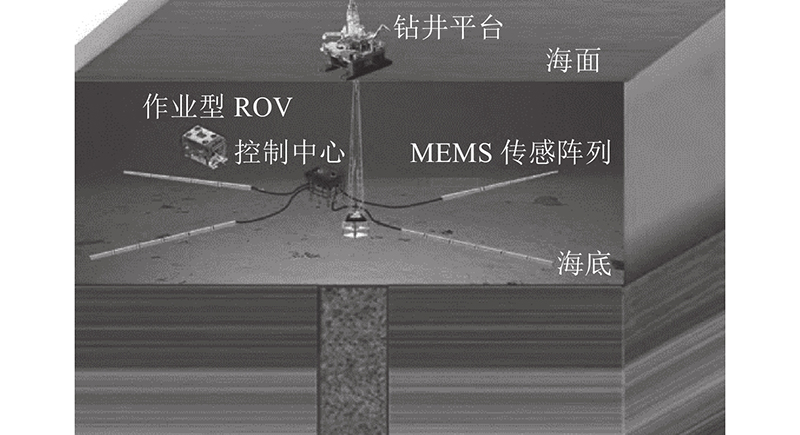
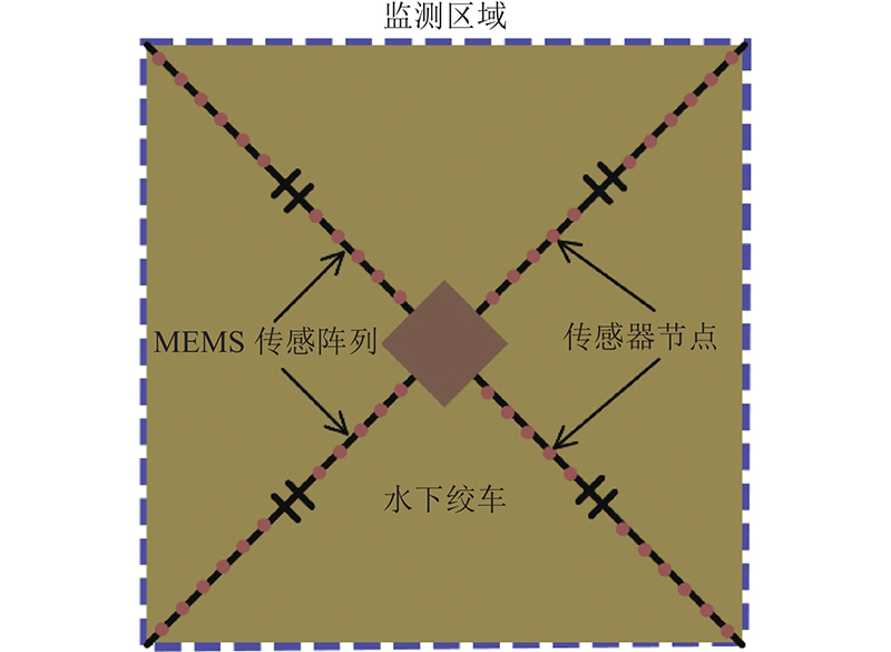
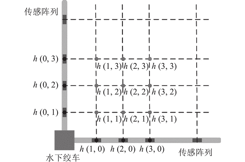
| 基于MEMS传感阵列的海底地形形变原位监测装置 |
葛勇强1( ),曹晨1,陈家旺1,2,*(),徐春莺3,周朋1,高峰1,梁涛1,方玉平1 ),曹晨1,陈家旺1,2,*(),徐春莺3,周朋1,高峰1,梁涛1,方玉平1 |
1. 浙江大学 海洋学院,浙江 舟山 316021
2. 海洋感知技术与装备教育部工程研究中心,浙江 舟山 316021
3. 汕头大学 工学院,广东 汕头 515013 |
|
| In-situ monitoring device for seabed terrain deformation based on MEMS sensor array |
| Yong-qiang GE1(),Chen CAO1,Jia-wang CHEN1,2,*(),Chun-ying XU3,Peng ZHOU1,Feng GAO1,Tao LIANG1,Yu-ping FANG1 |
1. Ocean College, Zhejiang University, Zhoushan 316021, China
2. The Engineering Research Center of Oceanic Sensing Technology and Equipment, Ministry of Education, Zhoushan 316021, China
3. College of Engineering, Shantou University, Shantou 515013, China |
引用本文:
葛勇强,曹晨,陈家旺,徐春莺,周朋,高峰,梁涛,方玉平. 基于MEMS传感阵列的海底地形形变原位监测装置[J]. 浙江大学学报(工学版), 2022, 56(9): 1732-1739.
Yong-qiang GE,Chen CAO,Jia-wang CHEN,Chun-ying XU,Peng ZHOU,Feng GAO,Tao LIANG,Yu-ping FANG. In-situ monitoring device for seabed terrain deformation based on MEMS sensor array. Journal of ZheJiang University (Engineering Science), 2022, 56(9): 1732-1739.
链接本文:
https://www.zjujournals.com/eng/CN/10.3785/j.issn.1008-973X.2022.09.006
或
https://www.zjujournals.com/eng/CN/Y2022/V56/I9/1732
|
| 1 |
RUPPEL C D, WAITE W F Grand challenge: timescales and processes of methane hydrate formation and breakdown, with application to geologic systems[J]. Journal of Geophysical Research: Solid Earth, 2020, 125 (8): e2018JB016459
|
| 2 |
YOU K, FLEMINGS P B, MALINVERNO A, et al Mechanisms of methane hydrate formation in geological systems[J]. Reviews of Geophysics, 2019, 57 (4): 1146- 1196
doi: 10.1029/2018RG000638
|
| 3 |
CHONG Z, YANG S, BABU P, et al Review of natural gas hydrates as an energy resource: prospects and challenges[J]. Applied Energy, 2016, 162: 1633- 1652
doi: 10.1016/j.apenergy.2014.12.061
|
| 4 |
XU C, CHEN J, ZHU H, et al Experimental research on seafloor mapping and vertical deformation monitoring for gas hydrate zone using nine-axis MEMS sensor tapes[J]. IEEE Journal of Oceanic Engineering, 2018, 44 (4): 1090- 1101
|
| 5 |
朱超祁, 张民生, 刘晓磊, 等 海底天然气水合物开采导致的地质灾害及其监测技术[J]. 灾害学, 2017, 32 (3): 51- 56
ZHU Chao-qi, ZHANG Min-sheng, LIU Xiao-lei, et al Gas hydrates: production, geohazards and monitoring[J]. Journal of Catastrophology, 2017, 32 (3): 51- 56
doi: 10.3969/j.issn.1000-811X.2017.03.010
|
| 6 |
XU C, CHEN J, YAN D, et al Review of underwater cable shape detection[J]. Journal of Atmospheric and Oceanic Technology, 2016, 33 (3): 597- 606
doi: 10.1175/JTECH-D-15-0112.1
|
| 7 |
李岳明, 李晔, 盛明伟, 等 AUV 搭载多波束声纳进行地形测量的现状及展望[J]. 海洋测绘, 2016, 36 (4): 7- 11
LI Yue-ming, LI Ye, SHENG Ming-wei, et al Application and development of topographic survey using multibeam echosounder equipped on AUV[J]. Hydrographic Surveying and Charting, 2016, 36 (4): 7- 11
doi: 10.3969/j.issn.1671-3044.2016.04.002
|
| 8 |
YOKOYAMA T, SHIMOYAMA M, MATSUDA S, et al. Monitoring system of seafloor subsidence for methane hydrate production test [C]// SPWLA 18th Formation Evaluation Symposium of Japan. Chiba: [s. n.], 2012, 23(3): 425–434.
|
| 9 |
SAITO H, YOKOYAMA T. Development of seafloor displacement monitoring system using a 3-component servo-accelerometer [C]// OCEANS 2008 – MTS/IEEE Kobe Techno-Ocean. Kobe: IEEE, 2008: 1-4.
|
| 10 |
辛明真. 基于GNSS-A浮标的水下非差定位关键技术研究[D]. 青岛: 山东科技大学, 2016.
Xin Ming-zhen. The research on key technologies of non-differential method based on GNSS-A buoys underwater positioning system [D]. Qingdao: Shandong University of Science and Technology, 2016.
|
| 11 |
杨元喜, 刘焱雄, 孙大军, 等. 2020. 海底大地基准网建设及其关键技术[J]. 中国科学: 地球科学, 50(7): 936-945.
YANG Yuan-xi, LIU Yan-xiong, SUN Da-jun, et al. Seafloor geodetic network establishment and key technologies [J]. SCIENTIA SINICA Terrae, 2020, 50(7): 936-945.
|
| 12 |
刘经南, 陈冠旭, 赵建虎, 等 海洋时空基准网的进展与趋势[J]. 武汉大学学报:信息科学版, 2019, 44 (1): 20- 40
LIU Jing-nan, CHEN Guan-xu, ZHAO Jian-hu, et al Development and trends of marine space-time frame network[J]. Geomatics and Information Science of Wuhan University, 2019, 44 (1): 20- 40
|
| 13 |
YOKOTA Y, ISHIKAWA T Shallow slow slip events along the nankai trough detected by GNSS-A[J]. Science Advances, 2020, 6 (3): eaay5786
doi: 10.1126/sciadv.aay5786
|
| 14 |
YOKOTA Y, ISHIKAWA T, WATANABE S I Seafloor crustal deformation data along the subduction zones around Japan obtained by GNSS-A observations[J]. Scientific Data, 2018, 5 (4): 2303- 2322
|
| 15 |
MISHORY J DARPA Eyes proposers’s day for undersea positioning system[J]. Inside the Pentagon, 2015, 31 (15): 11
|
| 16 |
ZHANG K, LI Y, ZHAO J, et al Underwater navigation based on real-time simultaneous sound speed profile correction[J]. Marine Geodesy, 2016, 39 (1): 98- 111
doi: 10.1080/01490419.2015.1082521
|
| 17 |
SCHERWATH M, THOMSEN L, RIEDEL M, et al Ocean observatories as a tool to advance gas hydrate research[J]. Earth and Space Science, 2019, 6 (12): 2644- 2652
doi: 10.1029/2019EA000762
|
| 18 |
XU C, CHEN J, GE Y, et al Monitoring the vertical changes of a tidal flat using a MEMS accelerometer array[J]. Applied Ocean Research, 2020, 101 (1): 102186
|
| 19 |
GE Y, CHEN J, CAO C, et al. Development and sea trial of the terrain monitoring device based on mems sensing array [C]// IOP Conference Series Earth and Environmental Science. Beijing: [s.n.], 2021, 861: 072008.
|
| 20 |
BENNETTP V, ABDOUN T, BARENDSE M Evaluation of soft clay field consolidation using mems-based in-place inclinometer-accelerometer array[J]. Geotechnical Testing Journal, 2015, 38 (3): 290- 302
|
| 21 |
ZHU C, JIA Y, WANG Z, et al Dynamics of bottom boundary layers in the yellow river subaqueous delta based on long-term in-situ observations[J]. Acta Geologica Sinica, 2017, 91 (1): 369- 370
doi: 10.1111/1755-6724.13095
|
| 22 |
PRIOR D B, SUHAYDA J N, LU N, et al Storm wave reactivation of a submarine landslide[J]. Nature, 1989, 341 (6237): 47
doi: 10.1038/341047a0
|
| 23 |
UCHIMURA T, TOWHATA I, WANG L, et al Precaution and early warning of surface failure of slopes using tilt sensors[J]. Soils and Foundations, 2015, 55 (5): 1086- 1099
doi: 10.1016/j.sandf.2015.09.010
|
| 24 |
CHEN J, CAO C, GE Y, et al Experimental research on data synchronous acquisition method of subsidence monitoring in submarine gas hydrate mining area[J]. Sensors, 2019, 19 (19): 4319
doi: 10.3390/s19194319
|
| 25 |
GE Y, CHEN J, CAO C, et al Design and test of a MEMS accelerometer array for submarine landslide displacement monitoring[J]. Marine Technology Society Journal, 2021, 55 (1): 5- 16
doi: 10.4031/MTSJ.55.1.7
|
|
Viewed |
|
|
|
Full text
|
|
|
|
|
Abstract
|
|
|
|
|
Cited |
|
|
|
|
| |
Shared |
|
|
|
|
| |
Discussed |
|
|
|
|