| Civil and St ructural Engineering |
|


|
|
|
| IFC-based data visualization of 3D Tiles for buildings |
Zhao XU1( ),Lu ZHANG1,Hua SUO2,Ying-zi CHI3 ),Lu ZHANG1,Hua SUO2,Ying-zi CHI3 |
1. School of Civil Engineering, Southeast University, Nanjing 210000, China
2. School of Architecture & Urban Planning, Guangzhou University, Guangzhou 510000, China
3. Nanjing Tech University Pujiang Institute, Nanjing 210000, China |
|
|
|
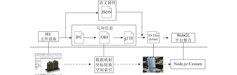
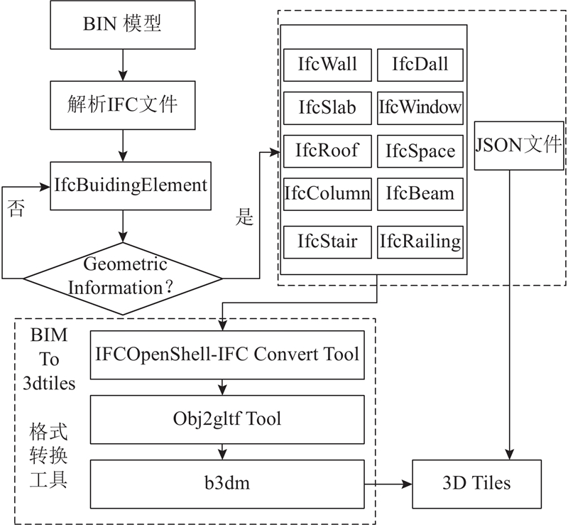
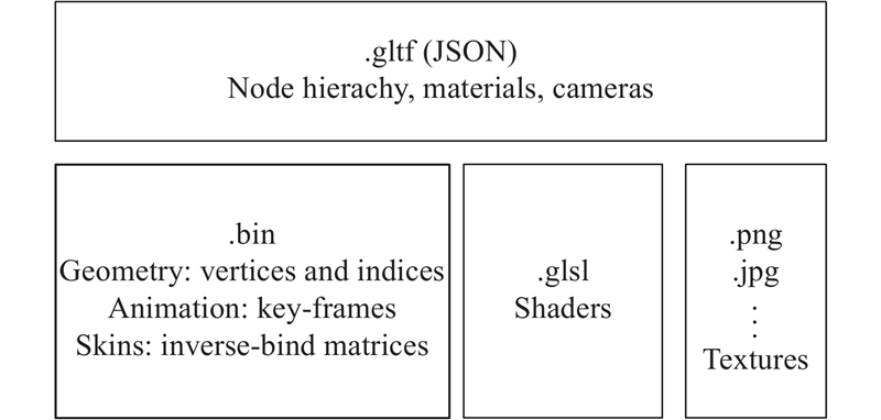
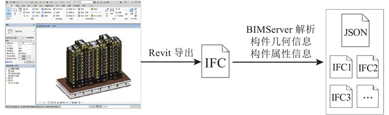
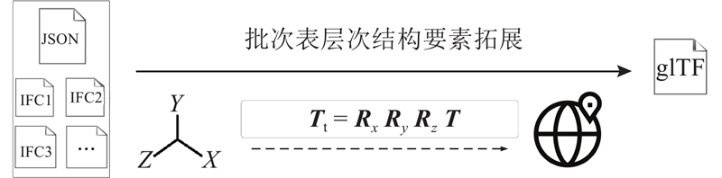
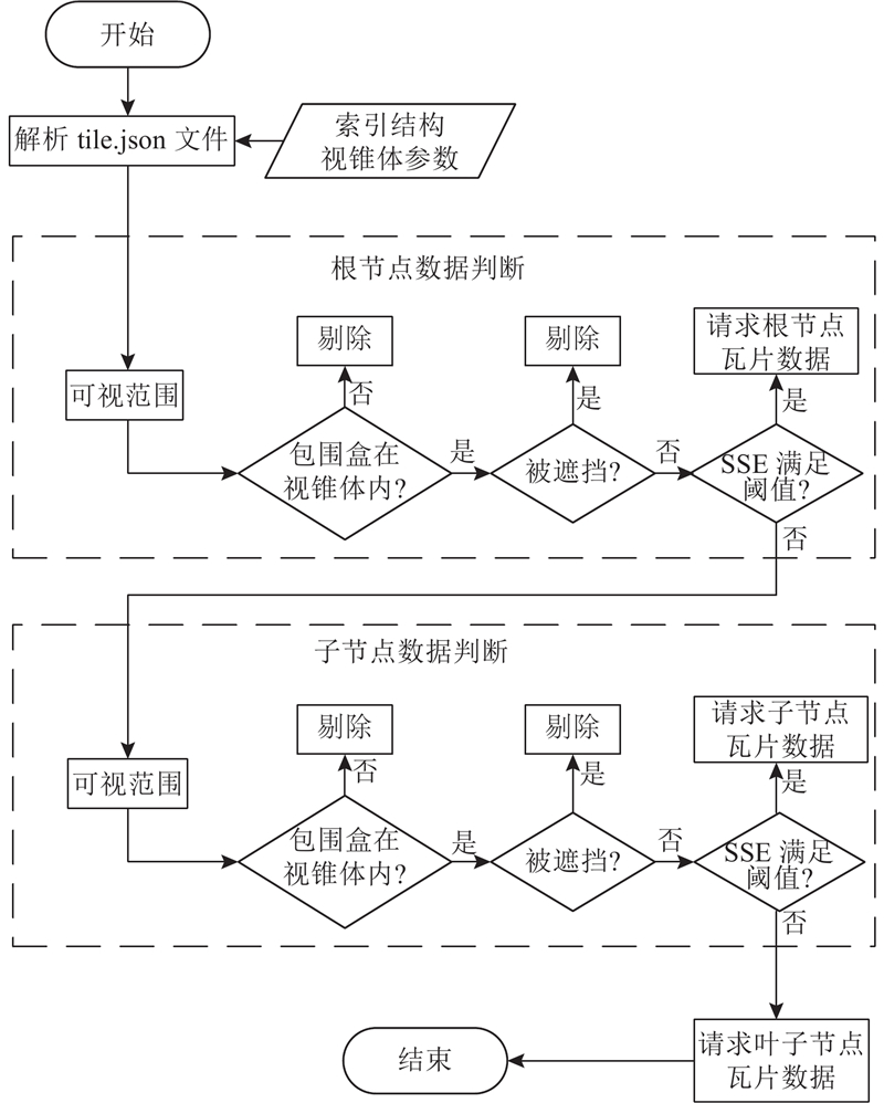
Abstract In view of the shortcomings of the network transmission and browser rendering in current BIM and GIS integration schemes, 3D Tiles in the GIS domain was chosen as the research object considering that it is more suitable to be loaded on webpages; the method was proposed to convert IFC to 3D Tiles for BIM models and to load BIM data quickly on Web; meanwhile, the integrated solution was analyzed to show BIM-GIS data massively on Web. The IFC data was taken as the starting point and splits BIM data according to the building component categories, and the geometry information and the semantic attributes were obtained. The geometry information file was converted by the intermediate format and finally encapsulated with the semantic attribute file to form 3D Tiles data with BIM semantic attributes. The coordinate conversion, data mapping, spatial index and levels of detail (LOD) hierarchical division are completed during the conversion process to ensure fast and efficient rendering interaction of BIM data and geographical feature data in the 3D WebGIS framework.
|
|
Received: 11 December 2018
Published: 22 May 2019
|
|
|
基于工业基础类的建筑物3D Tiles数据可视化
针对目前建筑信息模型(BIM)与地理信息系统(GIS)集成方案网络传输与浏览器渲染能力的不足,选择GIS领域更适合Web端加载的三维瓦片数据作为研究目标,提出BIM模型从工业基础类(IFC)向3D Tiles数据格式的转化方法和在Web端快速加载BIM模型的思路,并对GIS和BIM在Web端的大体量数据集成方案进行研究. 针对IFC标准模型数据,根据建筑构件划分标准对数据进行拆分,得到几何信息文件和语义属性文件. 几何信息文件经中间格式转换,最终与语义属性文件封装为保留有BIM语义属性的三维瓦片数据. 在转换过程中完成了坐标转换、数据映射、空间索引以及多细节层级(LOD)划分,实现了BIM数据和地理要素数据在三维WebGIS框架下快速、高效的渲染交互.
关键词:
工业基础类(IFC),
三维瓦片,
三维WebGIS,
建筑信息模型(BIM),
建筑物,
数据集成
|
|
| [1] |
KIM K, KIM H, KIM W, et al Integration of ifc objects and facility management work information using Semantic Web[J]. Automation in Construction, 2018, 87: 173- 187
doi: 10.1016/j.autcon.2017.12.019
|
|
|
| [2] |
KANG T W, HONG C H A study on software architecture for effective BIM/GIS-based facility management data integration[J]. Automation in Construction, 2015, 54: 25- 38
doi: 10.1016/j.autcon.2015.03.019
|
|
|
| [3] |
AMIREBRAHIMI S, RAJABIFARD A, MENDIS P, NGO T A BIM-GIS integration method in support of the assessment and 3D visualization of flood damage to a building[J]. Journal of Spatial Science, 2016, 61 (2): 317- 350
doi: 10.1080/14498596.2016.1189365
|
|
|
| [4] |
ZHU J X, WANG X Y, WANG P, et al Integration of BIM and GIS: geometry from IFC to shapefile using open-source technology[J]. Automation in Construction, 2019, 102: 105- 119
doi: 10.1016/j.autcon.2019.02.014
|
|
|
| [5] |
李德超, 张瑞芝 BIM技术在数字城市三维建模中的应用研究[J]. 土木建筑工程信息技术, 2012, 4 (1): 47- 51
LI De-chao, ZHANG Rui-zhi Research on applying BIM to build three-dimensional model of digital city[J]. Journal of Information Technology in Civil Engineering and Architecture, 2012, 4 (1): 47- 51
doi: 10.3969/j.issn.1674-7461.2012.01.009
|
|
|
| [6] |
汤圣君, 朱庆, 赵君峤 BIM与GIS数据集成: IFC与CityGML建筑几何语义信息互操作技术[J]. 土木建筑工程信息技术, 2014, 6 (4): 11- 17
TANG Sheng-jun, ZHU Qing, ZHAO Jun-qiao Towards interoperating of BIM and GIS model: geometric and semantic integration of CityGML and IFC building models[J]. Journal of Information Technology in Civil Engineering and Architecture, 2014, 6 (4): 11- 17
doi: 10.3969/j.issn.1674-7461.2014.04.002
|
|
|
| [7] |
LIU D W, PENG J. WANG Y Y, et al Implementation of interactive three-dimensional visualization of air pollutants using WebGL[J]. Environmental Modelling and Software, 2019, 114: 188- 194
|
|
|
| [8] |
王珩玮, 胡振中, 林佳瑞, 等 面向Web的BIM三维浏览与信息管理[J]. 土木建筑工程信息技术, 2013, 5 (3): 1- 7
WANG Heng-wei, HU Zhen-zhong, LIN Jia-rui, et al Web-oriented BIM 3D viewing and information management[J]. Journal of Information Technology in Civil Engineering and Architecture, 2013, 5 (3): 1- 7
doi: 10.3969/j.issn.1674-7461.2013.03.001
|
|
|
| [9] |
乐世华, 张煦, 张尚弘, 等 基于Cesium的WebGIS流域虚拟场景搭建[J]. 水利水电技术, 2018, 49 (5): 90- 96
LE Shi-hua, ZHANG Xu, ZHANG Shang-hong, et al Cesium-based construction of WebGIS watershed virtual scene[J]. Water Resources and Hydropower Engineering, 2018, 49 (5): 90- 96
|
|
|
| [10] |
高喆, 王佳, 周小平, 等 跨平台的建筑信息模型展示技术研究[J]. 建筑技术, 2017, 48 (4): 405- 407
GAO Zhe, WANG Jia, ZHOU Xiao-ping, et al Research on cross platform model display technology of BIM[J]. Architecture Technology, 2017, 48 (4): 405- 407
doi: 10.3969/j.issn.1000-4726.2017.04.019
|
|
|
| [11] |
黄桦, 王良清, 俞志强 面向流媒体传输的异构三维建筑模型转换方法及应用[J]. 测绘与空间地理信息, 2018, 41 (12): 119- 121
HUANG Hua, WANG Liang-qing, YU Zhi-qiang Transformation method and application of heterogeneous 3D building model for streaming media transmission[J]. Geomatics and Spatial Information Technology, 2018, 41 (12): 119- 121
|
|
|
| [12] |
KULAWIAK M, CHYBICKI A Application of Web-GIS and geovisual analytics to monitoring of seabed evolution in South Baltic Sea coastal areas[J]. Marine Geodesy, 2018, 41 (4): 405- 426
doi: 10.1080/01490419.2018.1469557
|
|
|
| [13] |
CHEN Y, SHOORAJ E, RAJABIFARD A, SABRI S From IFC to 3D Tiles: an integrated open-source solution for visualising BIMs on cesium[J]. ISPRS International Journal of Geo-Information, 2018, 7 (10): 393- 404
doi: 10.3390/ijgi7100393
|
|
|
| [14] |
DICK C, SCHNEIDER J, RUDIGER W Efficient geometry compression for GPU-based decoding in realtime terrain rendering[J]. Computer Graphics Forum, 2009, 28 (1): 67- 83
doi: 10.1111/cgf.2009.28.issue-1
|
|
|
| [15] |
HEATON J, PARLIKAD A K A conceptual framework for the alignment of infrastructure assets to citizen requirements within a Smart Cities framework[J]. Cities, 2019, 90: 32- 41
doi: 10.1016/j.cities.2019.01.041
|
|
|
|
Viewed |
|
|
|
Full text
|
|
|
|
|
Abstract
|
|
|
|
|
Cited |
|
|
|
|
| |
Shared |
|
|
|
|
| |
Discussed |
|
|
|
|