| Earth Science |
|


|
|
|
| Building extraction from high resolution remote sensing image based on samples morphological transformation |
Shu-hao RAN1( ),Yu-long HU2,Yuan-wei YANG1,*(),Xian-jun GAO1,3,Xi LI3,Ming-zhu CHEN1 ),Yu-long HU2,Yuan-wei YANG1,*(),Xian-jun GAO1,3,Xi LI3,Ming-zhu CHEN1 |
1. School of Geosciences, Yangtze University, Wuhan 430100, China
2. China Transport Telecommunications and Information Center, Beijing 100011
3. State Key Laboratory of Information Engineering in Surveying, Mapping and Remote Sensing, Wuhan University, Wuhan 430079, China |
|
|
|
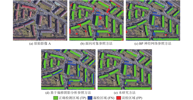
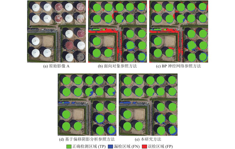
Abstract A building extraction method based on samples morphological transformation was proposed, aiming at the reduction of building extraction accuracy caused by the various spectral information on the building roof in the high-resolution remote sensing image. The shifted shadow analysis method was utilized to automatically extract the initial building samples. Rotation, offset, and zoom transformations were applied to the initial samples according to the roof shape characteristics of the building. And an adaptive sample fine extraction transformation combination was established so as to extract building samples more completely and comprehensively. The image was classified to obtain the initial extraction results of buildings, combined with the support vector machine (SVM) classifier. A grid proportion method based on morphological features was proposed to confirm the initial extraction results. The final buildings were extracted more accurately by eliminating irregular non-buildings. The comparative experiment analysis of high-resolution remote sensing images was conducted to assess the effectiveness of the proposed method. Comparison with three reference algorithms, i.e. object-oriented, back propagation (BP) neural network, and shifted shadow analysis, shows that the proposed method achieves a better accuracy of building extraction than the reference algorithms.
|
|
Received: 13 May 2019
Published: 05 May 2020
|
|
|
|
Corresponding Authors:
Yuan-wei YANG
E-mail: 201500880@yangtzeu.edu.cn;yyw_08@whu.edu.cn
|
基于样本形态变换的高分遥感影像建筑物提取
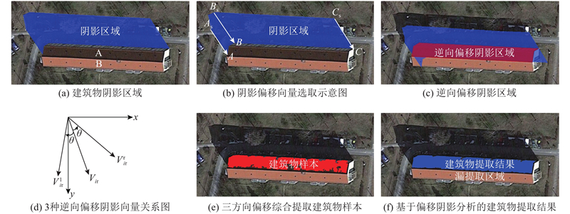
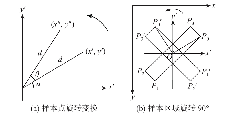
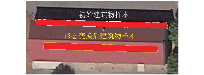
针对高分辨率遥感影像中建筑物屋顶光谱信息多变引起建筑物提取精度降低的问题,提出基于样本形态变换的建筑物提取方法. 利用偏移阴影分析法自动提取初始建筑物样本,根据建筑物屋顶形态特征,合理利用样本旋转、偏移、缩放变换方法,构建自适应样本精细提取变换组合,以更完整、全面地提取建筑物样本;结合支持向量机(SVM)分类器进行影像分类,得到建筑物初始提取结果;提出基于形态特征的格网占比法对初始提取结果进行确认,剔除不规则非建筑物,实现对建筑物的准确提取. 对高分辨率遥感影像进行对比实验分析,以验证方法的有效性. 结果表明,与面向对象分类、反向传播(BP)神经网络、基于偏移阴影分析3种参照方法对比,所提方法的建筑物提取精度均优于参照算法.
关键词:
高分辨率遥感影像,
建筑物样本提取,
偏移阴影分析,
样本形态变换,
格网占比法
|
|
| [1] |
FERRO A, BRUNNER D, BRUZZONE L Automatic detection and reconstruction of building radar footprints from single VHR SAR images[J]. IEEE Transactions on Geoscience and Remote Sensing, 2013, 51 (2): 935- 952
doi: 10.1109/TGRS.2012.2205156
|
|
|
| [2] |
YAN J H, ZHANG K Q, ZHANG C C, et al Automatic construction of 3-D building model from airborne LIDAR data through 2-D snake algorithm[J]. IEEE Transactions on Geoscience and Remote Sensing, 2015, 53 (1): 3- 14
doi: 10.1109/TGRS.2014.2312393
|
|
|
| [3] |
张志超. 融合机载与地面LIDAR数据的建筑物三维重建研究[D]. 武汉: 武汉大学, 2010.
ZHANG Zhi-chao. Airborne and terrestrial LIDAR data fusion for 3D building reconstruction [D]. Wuhan: Wuhan University, 2010.
|
|
|
| [4] |
RUTHER H, MARTINE H M, MTALO E G Application of snakes and dynamic programming optimisation technique in modeling of buildings in informal settlement areas[J]. Isprs Journal of Photogrammetry and Remote Sensing, 2002, 56 (4): 269- 282
doi: 10.1016/S0924-2716(02)00062-X
|
|
|
| [5] |
唐亮, 谢维信, 黄建军, 等 直线Snakes及其在建筑物提取中的应用[J]. 西安电子科技大学学报, 2005, 32 (1): 60- 65
TANG Liang, XIE Wei-xin, HUANG Jian-jun, et al Line snake and its application in Building extraction[J]. Journal of Xidian University, 2005, 32 (1): 60- 65
|
|
|
| [6] |
杨淼, 龚成龙, 魏志强 形态学尺度空间城市建筑物自动分类算法[J]. 中国图象图形学报, 2011, 16 (4): 579- 585
YANG Miao, GONG Cheng-long, WEI Zhi-qiang The automatic classification algorithm for urban buildings based on morphological scale-space[J]. Journal of Image and Graphics, 2011, 16 (4): 579- 585
doi: 10.11834/jig.091082
|
|
|
| [7] |
程曦冉, 张剑清, 张祖勋 航空影像多直角平顶房屋的半自动提取[J]. 武汉大学学报: 信息科学版, 2004, 29 (12): 1097- 1100
CHENG Xi-ran, ZHANG Jian-qing, ZHANG Zu-xun Semi-automatic extraction of houses with multi right angles from aerial images[J]. Geomatics and Information Science of Wuhan University, 2004, 29 (12): 1097- 1100
|
|
|
| [8] |
程效军, 程小龙, 胡敏捷, 等 融合航空影像和LIDAR点云的建筑物探测及轮廓提取[J]. 中国激光, 2016, 43 (5): 253- 261
CHENG Xiao-Jun, CHENG Xiao-long, HU Min-jie, et al Buildings detection and contour extraction by fusion of aerial images and LIDAR point cloud[J]. Chinese Journal of Lasers, 2016, 43 (5): 253- 261
|
|
|
| [9] |
ROTHER C, KOLMOGOROV V, BLAKE A "GrabCut": interactive foreground extraction using iterated graph cuts[J]. Acm Transactions on Graphics, 2004, 23 (3): 309- 314
doi: 10.1145/1015706.1015720
|
|
|
| [10] |
SIRMACEK B, UENSALAN C Urban-area and building detection using SIFT keypoints and graph theory[J]. IEEE Transactions on Geoscience and Remote Sensing, 2009, 47 (4): 1156- 1167
doi: 10.1109/TGRS.2008.2008440
|
|
|
| [11] |
TURKER M, KOC-SAN D Building extraction from high-resolution optical spaceborne images using the integration of support vector machine (SVM) classification, Hough transformation and perceptual grouping[J]. International Journal of Applied Earth Observation and Geoinformation, 2015, 34: 58- 69
doi: 10.1016/j.jag.2014.06.016
|
|
|
| [12] |
林雨准, 张保明, 徐俊峰, 等 多特征多尺度相结合的高分辨率遥感影像建筑物提取[J]. 测绘通报, 2017, (12): 53- 57
LIN Yu-zhun, ZHANG Bao-ming, XU Jun-feng, et al Building extraction from high resolution remote sensing imagery with multi-feature and multi-scale[J]. Bulletin of Surveying and Mapping, 2017, (12): 53- 57
|
|
|
| [13] |
GHAFFARIAN S, GHAFFARIAN S Automatic building detection based on purposive FastICA (PFICA) algorithm using monocular high resolution Google Earth images[J]. Isprs Journal of Photogrammetry and Remote Sensing, 2014, 97: 152- 159
doi: 10.1016/j.isprsjprs.2014.08.017
|
|
|
| [14] |
NIVEETHA M A, VIDHYA R. Automatic building extraction using advanced morphological operations and texture enhancing [C]// International Conference on ModellingOptimisation and Computing. TamilNadu: Elsevier, 2012: 3573-3578.
|
|
|
| [15] |
SUMER E, TURKER M An adaptive fuzzy-genetic algorithm approach for building detection using high-resolution satellite images[J]. Computers, Environment and Urban Systems, 2013, 39: 48- 62
doi: 10.1016/j.compenvurbsys.2013.01.004
|
|
|
| [16] |
SAN D K, TURKER M Building extraction from high resolution satellite images using Hough transform[J]. International Archives of the Photogrammetry, Remote Sensing and Spatial Information Science, 2010, 38 (1): 1063- 1068
|
|
|
| [17] |
高贤君, 郑学东, 刘子潇, 等 基于偏移阴影分析的高分辨率可见光影像建筑物自动提取[J]. 光学学报, 2017, 37 (4): 315- 324
GAO Xian-jun, ZHENG Xue-dong, LIU Zi-xiao, et al Automatic building extraction from very high resolution visible images on basis of shifted shadow analysis[J]. Acta Optica Sinica, 2017, 37 (4): 315- 324
|
|
|
| [18] |
高贤君, 万幼川, 杨元维, 等 高分辨率遥感影像阴影的自动检测与自动补偿[J]. 自动化学报, 2014, 40 (8): 1709- 1720
GAO Xian-jun, WAN You-chuan, YANG Yuan-wei, et al Automatic shadow detection and automatic compensation in high resolution remote sensing images[J]. Acta Automatica Sinica, 2014, 40 (8): 1709- 1720
|
|
|
| [19] |
曹琼.基于高分辨率遥感影像的建筑物提取研究[D]. 吉林: 吉林大学, 2018.
CAO Qiong. Research of building extraction based on high-resolution remote sensing images [D]. Jilin: Jilin University, 2018.
|
|
|
| [20] |
黄昕. 高分辨率遥感影像多尺度纹理、形状特征提取与面向对象分类研究[D]. 武汉: 武汉大学, 2009.
HUANG Xin. Multiscale texture and shape feature extraction and object-oriented classification for very high resolution remotely sensed imagery [D]. Wuhan: Wuhan University, 2009.
|
|
|
| [21] |
何灵敏, 沈掌泉, 孔繁胜, 等 SVM在多源遥感图像分类中的应用研究[J]. 中国图象图形学报, 2007, 12 (4): 648- 654
HE Ling-min, SHENG Zhang-quan, KONG Fan-sheng, et al Study on multi-source remote sensing images classification with SVM[J]. Journal of Image and Graphics, 2007, 12 (4): 648- 654
doi: 10.3969/j.issn.1006-8961.2007.04.015
|
|
|
| [22] |
WANG J, YANG X, QIN X, et al An efficient approach for automatic rectangular building extraction from very high resolution optical satellite imagery[J]. IEEE Geoscience and Remote Sensing Letters, 2015, 12 (3): 487- 491
doi: 10.1109/LGRS.2014.2347332
|
|
|
| [23] |
OK A O Automated detection of buildings from single VHR multispectral images using shadow information and graph cuts[J]. Isprs Journal of Photogrammetry and Remote Sensing, 2013, 86 (12): 21- 40
|
|
|
| [24] |
DAHIYA S, GARG P K, JAT M K. Object oriented approach for building extraction from high resolution satellite images [C]// IEEE InternationalAdvance Computing Conference (IACC). Ghaziabad: IEEE, 2013: 1300-1305.
|
|
|
|
Viewed |
|
|
|
Full text
|
|
|
|
|
Abstract
|
|
|
|
|
Cited |
|
|
|
|
| |
Shared |
|
|
|
|
| |
Discussed |
|
|
|
|