|
|
|
| Exterior deformation reconstruction of rockfill dam based on InSAR and multi-source data fusion |
Cheng-qian GUO1,2( ),Gang MA1,2,*(),Jiang-zhou MEI1,2,Gui-ke ZHANG3,Hong-bi LI3,Wei ZHOU1,2 ),Gang MA1,2,*(),Jiang-zhou MEI1,2,Gui-ke ZHANG3,Hong-bi LI3,Wei ZHOU1,2 |
1. State Key Laboratory of Water Resources and Hydropower Engineering Science, Wuhan University, Wuhan 430072, China
2. Key Laboratory of Rock Mechanics in Hydraulic Structural Engineering, Ministry of Education, Wuhan University, Wuhan 430072, China
3. Yalong River Basin Hydropower Development Limited Company, Chengdu 610051, China |
|
|
|
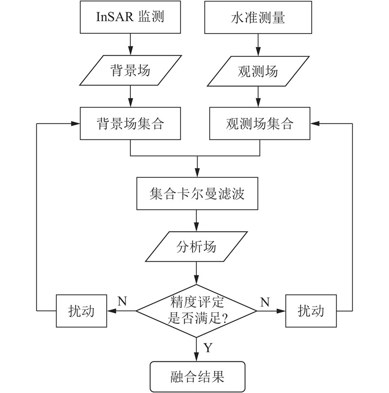
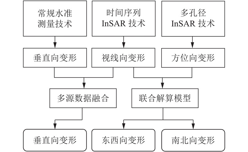
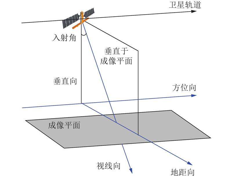
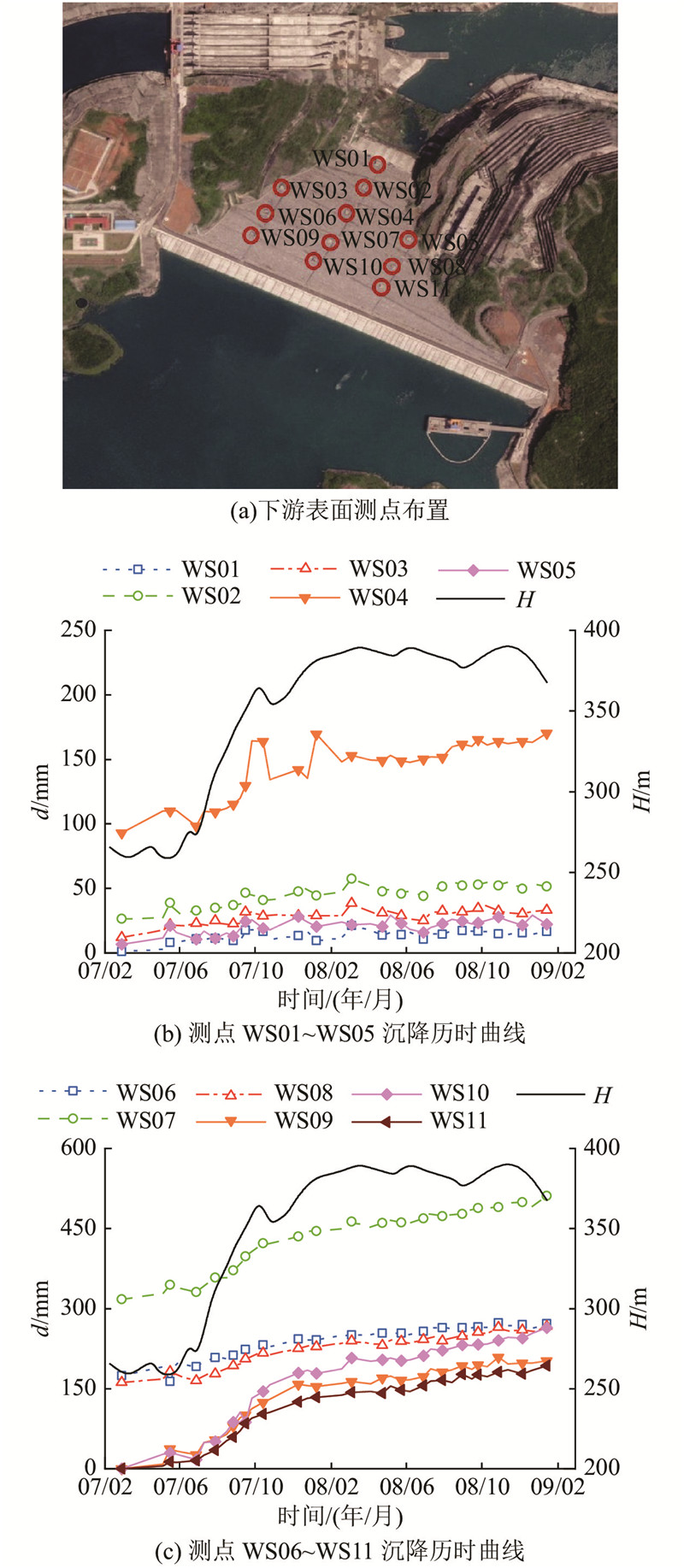
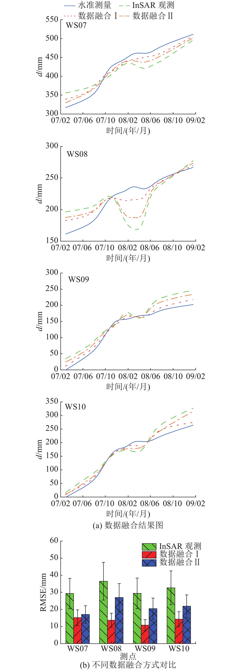
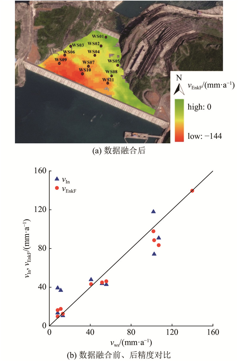
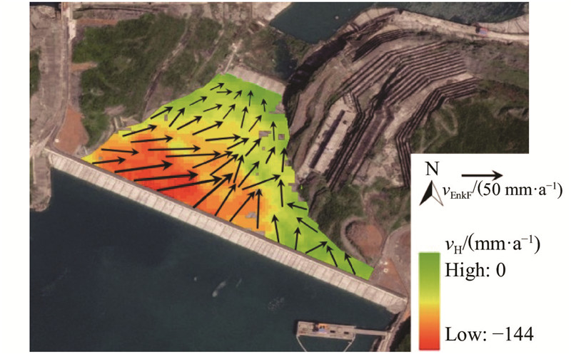
Abstract In order to meet the demand for deformation monitoring of rockfill dams of 200 m to 300 m, and to compensate for the deficiencies of using single-track synthetic aperture radar (SAR) data that can only measure two-dimensional deformation in the line of sight and azimuth directions, interferometric synthetic aperture radar (InSAR) measurements and conventional point monitoring data were fused across scales based on ensemble Kalman filtering to improve the monitoring accuracy of rockfill dam exterior deformation and multi-dimensional monitoring data were used to reconstruct exterior deformation field. Shuibuya concrete-face rockfill dam was taken as an example, and results show that the new monitoring technology with characteristic of “large range, low accuracy and high efficiency” and the conventional monitoring technology with characteristic of “discrete points, high accuracy and low efficiency” can complement each other through multi-source data fusion. By reconstructing the exterior deformation field based on multi-dimensional monitoring data, the overall deformation state of the rockfill dam can be comprehensively grasped and the possibility of missing or misjudging the actual deformation by using single-dimensional monitoring results can be reduced. The method can also be used for deformation monitoring and exterior deformation field reconstruction of the reservoir bank slopes.
|
|
Received: 14 September 2021
Published: 03 March 2022
|
|
|
|
Corresponding Authors:
Gang MA
E-mail: guochengqian@whu.edu.cn;magang630@whu.edu.cn
|
基于InSAR与多源数据融合的堆石坝外观变形重构
为了满足200~300 m级堆石坝变形监测的需求,弥补利用单轨道合成孔径雷达 (SAR)数据只能测得地物视线向与方位向二维变形的不足,基于集合卡尔曼滤波将合成孔径雷达干涉(InSAR)观测与常规点式监测数据进行跨尺度融合,提高堆石坝外观变形的监测精度;利用多维度监测数据,重构堆石坝外观变形场. 以水布垭面板堆石坝为例进行研究,结果表明,多源数据融合能够实现“大范围、低精度、高效率”的新型监测技术与“离散点、高精度、低效率”的常规监测技术的优势互补. 基于多维度监测数据重构外观变形场能够全面地掌握堆石坝的整体变形性态,降低单维度监测结果对实际变形漏判或误判的可能性. 该方法可以用于库岸边坡的变形监测和变形场重构.
关键词:
堆石坝,
数据融合,
合成孔径雷达干涉(InSAR),
集合卡尔曼滤波(EnKF),
变形重构
|
|
| [1] |
徐泽平 混凝土面板堆石坝关键技术与研究进展[J]. 水利学报, 2019, 50 (1): 62- 74
XU Ze-ping Research progresses and key technologies of CFRD construction[J]. Journal of Hydraulic Engineering, 2019, 50 (1): 62- 74
|
|
|
| [2] |
钮新强 高面板堆石坝安全与思考[J]. 水力发电学报, 2017, 36 (1): 104- 111
NIU Xin-qiang Security of high concrete face rockfill dam consideration and conclusion[J]. Journal of Hydroelectric Engineering, 2017, 36 (1): 104- 111
doi: 10.11660/slfdxb.20170113
|
|
|
| [3] |
陈楷, 邹德高, 孔宪京, 等 多边形比例边界有限单元非线性化方法及应用[J]. 浙江大学学报:工学版, 2017, 51 (10): 1996- 2004+2018
CHEN Kai, ZOU De-gao, KONG Xian-jing, et al Novel nonlinear polygon scaled boundary finite element method and its application[J]. Journal of Zhejiang University: Engineering Science, 2017, 51 (10): 1996- 2004+2018
|
|
|
| [4] |
靳聪聪, 迟世春 高心墙堆石坝弹塑性动力反应分析及地震易损性研究[J]. 浙江大学学报:工学版, 2020, 54 (7): 1390- 140
JIN Cong-cong, CHI Shi-chun Elasto-plastic dynamic response analysis and seismic fragility research of high core earth-rockfill dam[J]. Journal of Zhejiang University: Engineering Science, 2020, 54 (7): 1390- 140
|
|
|
| [5] |
冷天培, 马刚, 向正林, 等. 基于时序分解与深度学习的堆石坝变形预测[EB/OL]. [2021-09-12]. http://kns.cnki.net/kcms/detail/11.2241.TV.20210618.1419.002.html.
LENG Tian-pei, MA Gang, XIANG Zheng-lin, et al. Deformation prediction of rockfill dam based on time series decomposition and deep learning[EB/OL]. [2021-09-12]. http://kns.cnki.net/kcms/detail/11.2241.TV.20210618.1419.002.html.
|
|
|
| [6] |
马刚, 常晓林, 周伟, 等 高堆石坝瞬变-流变参数三维全过程联合反演方法及变形预测[J]. 岩土力学, 2012, 33 (6): 1889- 1895
MA Gang, CHANG Xiao-lin, ZHOU Wei, et al Integrated inversion of instantaneous and rheological parameters and deformation prediction of high rockfill dam[J]. Rock and Soil Mechanics, 2012, 33 (6): 1889- 1895
doi: 10.3969/j.issn.1000-7598.2012.06.044
|
|
|
| [7] |
杨荷, 周伟, 马刚, 等 基于响应面法的高堆石坝瞬变-流变参数反演方法[J]. 岩土力学, 2016, 37 (6): 1697- 1705
YANG He, ZHOU Wei, MA Gang, et al Inversion of instantaneous and rheological parameters of high rockfill dams based on response surface method[J]. Rock and Soil Mechanics, 2016, 37 (6): 1697- 1705
|
|
|
| [8] |
李少林, 周伟, 马刚, 等 基于改进遗传交叉算子的高心墙堆石坝参数反演[J]. 中南大学学报:自然科学版, 2016, 47 (8): 2730- 2737
LI Shao-lin, ZHOU Wei, MA Gang, et al Inversion of mechanical parameters of high central core rock-fill dam based on modified genetic crossover operator[J]. Journal of Central South University: Science and Technology, 2016, 47 (8): 2730- 2737
|
|
|
| [9] |
廖明生, 王腾. 时间序列 InSAR 技术与应用[M]. 北京: 科学出版社, 2014.
|
|
|
| [10] |
MILILLO P, PERISSIN D, SALZER J T, et al Monitoring dam structural health from space: insights from novel InSAR techniques and multi-parametric modeling applied to the Pertusillo dam Basilicata, Italy[J]. International Journal of Applied Earth Observation and Geoinformation, 2016, 52: 221- 229
doi: 10.1016/j.jag.2016.06.013
|
|
|
| [11] |
ZHOU W, LI S, ZHOU Z, et al Remote sensing of deformation of a high concrete-faced rockfill dam using InSAR: a study of the Shuibuya dam, China[J]. Remote Sensing, 2016, 8 (3): 255
doi: 10.3390/rs8030255
|
|
|
| [12] |
胡俊. 基于现代测量平差的InSAR三维形变估计理论与方法[D]. 长沙: 中南大学, 2013.
HU Jun. Theory and method of estimating three-dimensional displacement with InSAR based on the modern surveying adjustment[D]. Changsha: Central South University, 2013.
|
|
|
| [13] |
钟登华, 王飞, 吴斌平, 等 从数字大坝到智慧大坝[J]. 水力发电学报, 2015, 34 (10): 1- 13
ZHONG Deng-hua, WANG Fei, WU Bin-ping, et al From digital dam toward smart dam[J]. Journal of Hydroelectric Engineering, 2015, 34 (10): 1- 13
doi: 10.11660/slfdxb.20151001
|
|
|
| [14] |
HANSSEN R F. Radar interferometry: data interpretation and error analysis[M]. Berlin: Springer Science and Business Media, 2001.
|
|
|
| [15] |
张良培, 沈焕锋 遥感数据融合的进展与前瞻[J]. 遥感学报, 2016, 20 (5): 1050- 1061
ZHANG Liang-pei, SHEN Huan-feng Progress and future of remote sensing data fusion[J]. Journal of Remote Sensing, 2016, 20 (5): 1050- 1061
|
|
|
| [16] |
EVENSEN G The ensemble Kalman filter: theoretical formulation and practical implementation[J]. Ocean Dynamics, 2003, 53 (4): 343- 367
doi: 10.1007/s10236-003-0036-9
|
|
|
| [17] |
WRIGHT T J, PARSONS B E, LU Z Toward mapping surface deformation in three dimensions using InSAR[J]. Geophysical Research Letters, 2004, 31 (1): L01607
|
|
|
| [18] |
JOUGHIN I R, KWOK R, FAHNESTOCK M A Interferometric estimation of three-dimensional ice-flow using ascending and descending passes[J]. Geoscience and Remote Sensing IEEE Transactions on, 1998, 36 (1): 25- 37
doi: 10.1109/36.655315
|
|
|
| [19] |
BECHOR N, ZEBKER H A Measuring two-dimensional movements using a single InSAR pair[J]. Geophysical Research Letters, 2006, 33 (16): 275- 303
|
|
|
| [20] |
杨红磊, 彭军还 基于DInSAR和MAI技术揭示地震三维形变场[J]. 地球物理学进展, 2014, 29 (6): 2580- 2586
YANG Hong-lei, PENG Jun-huan Mapping three-dimensional co-seismic deformation by combining multiple-aperture interferometry and differential interferometric synthetic aperture radar[J]. Progress in Geophysics, 2014, 29 (6): 2580- 2586
doi: 10.6038/pg20140616
|
|
|
| [21] |
FERRETTI A, PRATI C, ROCCA F Nonlinear subsidence rate estimation using permanent scatterers in differential SAR interferometry[J]. IEEE Transactions on Geoscience and Remote Sensing, 2002, 38 (5): 2202- 2212
|
|
|
| [22] |
BERARDINO P, FORNARO G, LANARI R, et al A new algorithm for surface deformation monitoring based on small baseline differential SAR interferograms[J]. IEEE Transactions on Geoscience and Remote Sensing, 2002, 40 (11): 2375- 2383
doi: 10.1109/TGRS.2002.803792
|
|
|
| [23] |
HOOPER A, ZEBKER H A Phase unwrapping in three dimensions with application to InSAR time series[J]. Journal of the Optical Society of America A: Optics Image Science and Vision, 2007, 24 (9): 2737- 2747
doi: 10.1364/JOSAA.24.002737
|
|
|
| [24] |
党发宁, 杨超, 薛海斌, 等 河谷形状对面板堆石坝变形特性的影响研究[J]. 水利学报, 2014, 45 (4): 435- 442
DANG Fa-ning, YANG Chao, XUE Hai-bin, et al The effect of valley topography on deformation properties of CFRD[J]. Journal of Hydraulic Engineering, 2014, 45 (4): 435- 442
|
|
|
|
Viewed |
|
|
|
Full text
|
|
|
|
|
Abstract
|
|
|
|
|
Cited |
|
|
|
|
| |
Shared |
|
|
|
|
| |
Discussed |
|
|
|
|