| 地球科学 |
|

|
|
|
| 浙江省水域系统时空变化特征及驱动力分析 |
杨昀则1,田鹏2,李加林2,3,4( ),曹罗丹2,张海涛2,艾顺毅2 ),曹罗丹2,张海涛2,艾顺毅2 |
1.宁波大学 土木工程与环境学院,浙江 宁波 315211
2.宁波大学 地理与空间信息技术系,浙江 宁波 315211
3.宁波大学 东海战略研究院,浙江 宁波 315211
4.宁波陆海国土空间利用与治理协同创新中心,浙江 宁波 315211 |
|
| Analysis on the characteristics and driving forces of spatiotemporal changes of Zhejiang water system |
| Yunze YANG1,Peng TIAN2,Jialin LI2,3,4(),Luodan CAO2,Haitao ZHANG2,Shunyi AI2 |
1.School of Civil and Environment Engineering,Ningbo University,Ningbo 315211,Zhejiang Province,China
2.Department of Geography and Spatial Information Techniques,Ningbo University,Ningbo 315211,Zhejiang Province,China
3.Donghai Academy,Ningbo University,Ningbo 315211,Zhejiang Province,China
4.Collaborative Innovation Center for Land and Marine Spatial Utilization and Governance Research at Ningbo University,Ningbo 315211,Zhejiang Province,China |
引用本文:
杨昀则,田鹏,李加林,曹罗丹,张海涛,艾顺毅. 浙江省水域系统时空变化特征及驱动力分析[J]. 浙江大学学报(理学版), 2022, 49(4): 508-520.
Yunze YANG,Peng TIAN,Jialin LI,Luodan CAO,Haitao ZHANG,Shunyi AI. Analysis on the characteristics and driving forces of spatiotemporal changes of Zhejiang water system. Journal of Zhejiang University (Science Edition), 2022, 49(4): 508-520.
链接本文:
https://www.zjujournals.com/sci/CN/10.3785/j.issn.1008-9497.2022.04.015
或
https://www.zjujournals.com/sci/CN/Y2022/V49/I4/508
|
| 1 |
丁圣彦, 曹新向. 清末以来开封市水域景观格局变化[J]. 地理学报, 2004, 59(6): 956-963. doi:10.11821/xb200406019
DING S Y, CAO X X. Landscape pattern dynamics of water body in Kaifeng city since the end of the Qing dynasty (AD1898-2002) [J]. Acta Geographica Sinica, 2004, 59(6): 956-963. doi:10.11821/xb200406019
doi: 10.11821/xb200406019
|
| 2 |
WU Y F, ZHANG X, LI C, et al. Ecosystem service trade-offs and synergies under influence of climate and land cover change in an afforested semiarid basin, China[J]. Ecological Engineering, 2021, 159: 106083. DOI:10.1016/j.ecoleng.2020.106083
doi: 10.1016/j.ecoleng.2020.106083
|
| 3 |
朱利英, 魏源送, 王春荣, 等. 1980—2015年北运河流域土地利用时空变异及其对生态服务价值的影响[J]. 环境科学学报, 2021, 41(1): 301-310. DOI:10.13671/j.hjkxxb.2020.0515
ZHU L Y, WEI Y S, WANG C R, et al. Spatio-temporal evolution of land use and their impacts on ecosystem service values in North Canal River watershed during 1980-2015[J]. Acta Scientiae Circumstantiae, 2021, 41(1): 301-310. DOI:10. 13671/j.hjkxxb.2020.0515
doi: 10. 13671/j.hjkxxb.2020.0515
|
| 4 |
田晶, 郭生练, 刘德地, 等. 气候与土地利用变化对汉江流域径流的影响[J]. 地理学报, 2020, 75(11): 2307-2318. doi:10.11821/dlxb202011003
TIAN J, GUO S L, LIU D D, et al. Impacts of climate and land use/cover changes on runoff in the Hanjiang River Basin[J]. Acta Geographica Sinica, 2020, 75(11): 2307-2318. doi:10.11821/dlxb202011003
doi: 10.11821/dlxb202011003
|
| 5 |
蔡宏, 林国敏, 康文华. 赤水河流域中上游坡地景观特征对河流水质的影响[J]. 地理研究, 2018, 37(4): 704-716.
CAI H, LIN G M, KANG W H. The effects of sloping landscape features on water quality in the upper and middle reaches of the Chishui River Watershed[J]. Geographical Research, 2018, 37(4): 704-716.
|
| 6 |
LIANG J, HUANG C L, STEVENSON M A, et al. Changes in summer diatom composition and water quality in urban lakes within a metropolitan area in central China[J]. International Review of Hydrobiology, 2020, 105(3/4): 94-105. DOI:10. 1002/iroh.201801953
doi: 10. 1002/iroh.201801953
|
| 7 |
PASCO A, MINASSIAN A T, CHAPON C, et al. Dynamics of cerebral edema and the apparent diffusion coefficient of water changes in patients with severe traumatic brain injury: A prospective MRI study[J]. European Radiology, 2006, 16(7):1501-1508. DOI:10.1007/s00330-005-0086-0
doi: 10.1007/s00330-005-0086-0
|
| 8 |
陈艳, 刘绥华, 王堃, 等. 基于Landsat卫星影像的草海水质遥感反演及营养状态评价[J].水生态学杂志, 2020, 41(3): 24-31. DOI:10.15928/j.1674-3075. 2020.03.004
CHEN Y, LIU S H, WANG K, et al. Remote sensing of Caohai Lake quality using Landsat satellite images[J]. Journal of Hydroecology, 2020, 41(3): 24-31. DOI:10.15928/j.1674-3075.2020.03.004
doi: 10.15928/j.1674-3075.2020.03.004
|
| 9 |
李加林, 田鹏, 邵姝遥, 等. 中国东海区大陆岸线变迁及其开发利用强度分析[J]. 自然资源学报, 2019, 34(9): 1886-1901. DOI:10.31497/zrzyxb.20190907
LI J L, TIAN P, SHAO S Y, et al. The change of continental coastline and its development and utilization intensity in the East China Sea[J]. Journal of Natural Resources, 2019, 34(9): 1886-1901. DOI:10.31497/zrzyxb.20190907
doi: 10.31497/zrzyxb.20190907
|
| 10 |
TIAN P, CAO L D, LI J L, et al. Landscape grain effect in Yancheng Coastal Wetland and its response to landscape changes[J]. International Journal of Environmental Research and Public Health, 2019, 16(12): 2225. DOI:10.3390/ijerph16122225
doi: 10.3390/ijerph16122225
|
| 11 |
李云龙, 孔祥伦, 韩美, 等. 1986—2016年黄河三角洲地表水体变化及其驱动力分析[J]. 农业工程学报, 2019, 35(16): 105-113. DOI:10.11975/j.issn. 1002-6819.2019.16.012
LI Y L, KONG X L, HAN M, et al. Analysis of surface water changes and driving force in Yellow River Delta from 1986 to 2016[J]. Transactions of the Chinese Society of Agricultural Engineering, 2019, 35(16): 105-113. DOI:10.11975/j.issn.1002-6819.2019.16.012
doi: 10.11975/j.issn.1002-6819.2019.16.012
|
| 12 |
程东亚, 李旭东, 杨江州. 西南山地流域NDVI变化特征及降水敏感性:以贵州沅江流域为例[J]. 生态学报, 2020, 40(4): 1161-1174. DOI:10.5846/stxb 201812282832
CHENG D Y, LI X D, YANG J Z. Research on NDVI variation characteristics and precipitation sensitivity of the Yuanjiang River Basin in Guizhou province[J]. Acta Ecologica Sinica, 2020, 40(4): 1161-1174. DOI:10.5846/stxb201812282832
doi: 10.5846/stxb201812282832
|
| 13 |
杨利, 石彩霞, 谢炳庚. 长江流域国家湿地公园时空演变特征及其驱动因素[J]. 经济地理, 2019, 39(11): 194-202. DOI:10.15957/j.cnki.jjdl.2019. 11.023
YANG L, SHI C X, XIE B G. Temporal and spatial pattern evolution characteristics and driving factors of National Wetland Parks in the Yangtze River Basin[J]. Economic Geography, 2019, 39(11): 194-202. DOI:10.15957/j.cnki.jjdl.2019.11.023
doi: 10.15957/j.cnki.jjdl.2019.11.023
|
| 14 |
NAJJARI A, ELSHAHED M S, CHERIF A, et al. Patterns and determinants of halophilic archaea (class halobacteria) diversity in Tunisian endorheic salt lakes and sebkhet systems[J]. Applied and Environmental Microbiology, 2015,81(13): 4432-4441. DOI:10. 1128/aem.01097-15
doi: 10. 1128/aem.01097-15
|
| 15 |
田鹏, 李加林, 史小丽, 等. 浙江省土地利用格局时空变化及生态风险评价[J]. 长江流域资源与环境, 2018, 27(12): 2697-2706. DOI:10.11870/cjlyzyyhj 201812006
TIAN P, LI J L, SHI X L, et al. Spatial and temporal changes of land use pattern and ecological risk assessment in Zhejiang province[J]. Resources and Environment in the Yangtze Basin, 2018, 27(12): 2697-2706. DOI:10.11870/cjlyzyyhj201812006
doi: 10.11870/cjlyzyyhj201812006
|
| 16 |
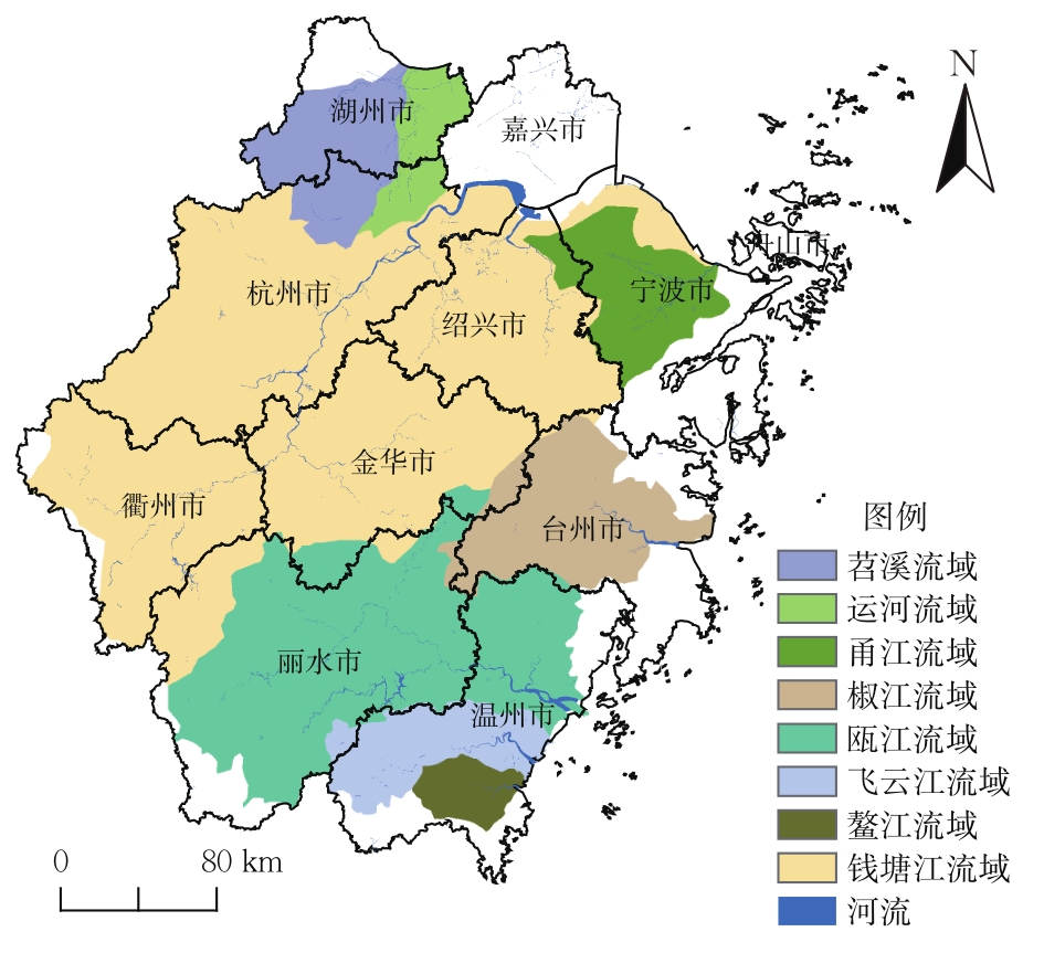
浙江省水利厅. 浙江省河流手册[M]. 北京: 中国水利水电出版社, 2016. doi:10.26789/aeb.2017.01.002
Water Resources Department of Zhejiang. Handbook of River in Zhejiang[M]. Beijing: China Water & Power Press, 2016. doi:10.26789/aeb.2017.01.002
doi: 10.26789/aeb.2017.01.002
|
| 17 |
TIAN P, LI J, CAO L, et al. Impacts of reclamation derived land use changes on ecosystem services in a typical gulf of Eastern China: A case study of Hangzhou Bay[J]. Ecological Indicators, 2021, 132: 108259. DOI:10.1016/j.ecolind.2021.108259
doi: 10.1016/j.ecolind.2021.108259
|
| 18 |
余春雪, 苏吉凯, 郭倩, 等. 中国河湖沼系统时空变化特征及驱动力影响分析[J]. 水生态学杂志, 2020, 41(5): 1-12. DOI:10.15928/j.1674-3075.2020.05.001
YU C X, SU J K, GUO Q, et al. Spatiotemporal changes and driving forces of river-lake-marsh systems in China[J]. Journal of Hydroecology, 2020, 41(5): 1-12. DOI:10.15928/j.1674-3075. 2020.05.001
doi: 10.15928/j.1674-3075. 2020.05.001
|
| 19 |
彭凯锋, 蒋卫国, 侯鹏, 等. 三江源国家公园植被时空变化及其影响因子[J]. 生态学杂志, 2020, 39(10): 3388-3396. DOI:10.13292/j.1000-4890. 202010.019
PENG K F, JIANG W G, HOU P, et al. Spatiotemporal variation of vegetation coverage and its affecting factors in the Three-River-Source National Park[J]. Chinese Journal of Ecology, 2020, 39(10): 3388-3396. DOI:10.13292/j.1000-4890. 202010.019
doi: 10.13292/j.1000-4890. 202010.019
|
| 20 |
王莺, 闫正龙, 高凡. 1957—2015年红碱淖湖水域面积时空变化监测及驱动力分析[J]. 农业工程学报, 2018, 34(2): 265-271. DOI:10.11975/j.issn.1002-6819.2018.02.036
WANG Y, YAN Z L, GAO F. Monitoring spatio-temporal changes of water area in Hongjiannao Lake from 1957 to 2015 and its driving forces analysis[J]. Transactions of the Chinese Society of Agricultural Engineering, 2018, 34(2): 265-271. DOI:10.11975/j.issn.1002-6819.2018.02.036
doi: 10.11975/j.issn.1002-6819.2018.02.036
|
|
Viewed |
|
|
|
Full text
|
|
|
|
|
Abstract
|
|
|
|
|
Cited |
|
|
|
|
| |
Shared |
|
|
|
|
| |
Discussed |
|
|
|
|