|
|
|
| Automatic extraction of spatially relevant 3D LiDAR railway support facility |
Yuan-wei YANG1,2,3( ),Yue ZHANG1,Xian-jun GAO1,Bing-jie MA1,Shen-ao GUO1,Lei XU4 ),Yue ZHANG1,Xian-jun GAO1,Bing-jie MA1,Shen-ao GUO1,Lei XU4 |
1. School of Geosciences, Yangtze University, Wuhan 430100, China
2. Hunan Provincial Key Laboratory of Geo-Information Engineering in Surveying, Mapping and Remote Sensing, Hunan University of Science and Technology, Xiangtan 411201, China
3. Beijing Key Laboratory of Urban Spatial Information Engineering, Beijing Institute of Surveying and Mapping, Beijing 100045, China
4. China Railway Design Corporation Limited Company, Tianjin 300251, China |
|
|
|
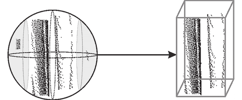
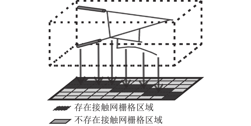
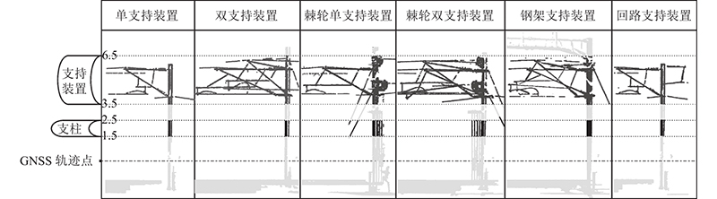
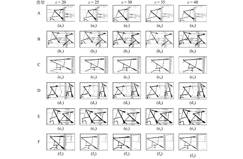
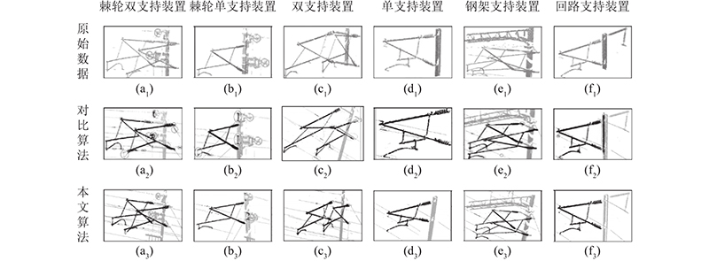
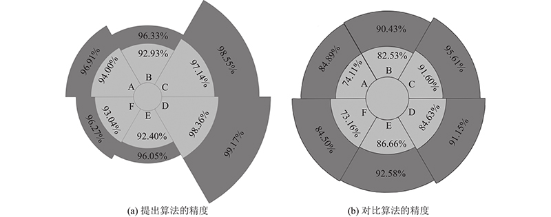
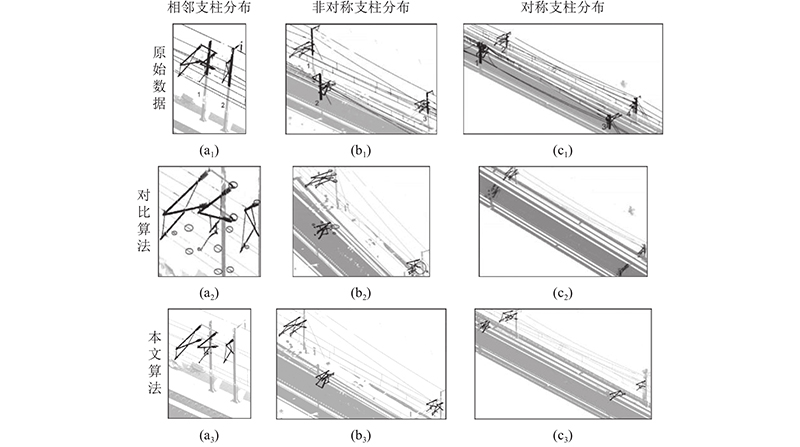
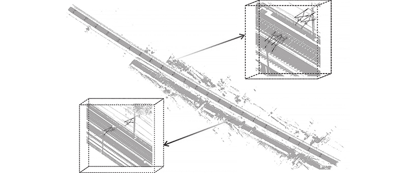
Abstract An automatic extraction algorithm of 3D LiDAR support facilities considering the spatial relationship was proposed in order to improve the extraction reliability and accuracy of multi-type support facilities. The key trajectory points were obtained by thinning the GNSS trajectory points. Then the original data was layered and divided into blocks to obtain the original point cloud pillar and support device data area. The center point of the pillar was obtained through the neighborhood search, and a spatial index was constructed based on the spatial relationship between the trajectory point and the search layer of the support device. The index was used as the driving force to realize the initial extraction of the support device and obtain the support device containing the contact line. The column search and parametric projection filtering were introduced to filter out the contact line point cloud for optimization of extraction results. The test results show that the algorithm has more than 93% MIoU and 94% Dice coefficient for extracting support facilities, which can consider multiple types of support facilities and has strong robustness and application value.
|
|
Received: 13 January 2022
Published: 25 October 2022
|
|
|
| Fund: 城市轨道交通数字化建设与测评技术国家工程实验室开放课题基金资助项目(2021ZH02);湖南科技大学测绘遥感信息工程湖南省重点实验室开放基金资助项目(E22133);城市空间信息工程北京市重点实验室经费资助项目(20210205);海南省地球观测重点实验室开放基金资助项目(2020LDE001);长江大学大学生创新创业训练计划资助项目(Dk2021013) |
顾及空间关系的3D LiDAR铁路支持装置自动提取
为了提高不同类型支持装置在不同场景中的提取可靠性及精度,提出顾及空间关系的3D LiDAR支持装置自动提取算法. 通过对GNSS轨迹点抽稀处理获取关键轨迹点,对原始数据进行分层、分块处理,获取原始点云支柱,支持装置数据区域. 通过邻域搜索获取支柱中心点,依据其与轨迹点和支持装置搜索层的空间关系构建空间索引. 以该索引为驱动实现支持装置的初提取,获取含有接触线的支持装置,引入柱状搜索、参数化投影滤波的方式滤除接触线点云,实现提取结果的优化. 经过测试可知,该算法对提取支持装置的MIoU均超过93%,Dice系数均超过94%,可以兼顾多类型支持装置,具有较强的鲁棒性和应用价值.
关键词:
接触网检测,
空间索引,
三维激光点云,
支持装置提取,
点云邻域搜索
|
|
| [1] |
宋章, 张广泽, 蒋良文, 等 川藏铁路主要地质灾害特征及地质选线探析[J]. 铁道标准设计, 2016, 60 (1): 14- 19
SONG Zhang, ZHANG Guang-ze, JIANG Liang-wen, et al Analysis of the characteristics of major geological disasters and geological alignment of Sichuan-Tibet railway[J]. Railway Sta-ndard Design, 2016, 60 (1): 14- 19
|
|
|
| [2] |
AGGARWAL R K, JOHNS A T, JAYASINGHE J A S B An overview of the condition monitoring of overhead lines[J]. Electric Power Systems Research, 2000, 53 (1): 15- 22
|
|
|
| [3] |
牛英杰, 苏燕辰, 程敦诚, 等 高铁接触网U型抱箍螺母故障检测算法[J]. 浙江大学学报: 工学版, 2021, 55 (10): 1912- 1921
NIU Ying-jie, SU Yan-chen, CHENG Dun-cheng, et al High-speed rail contact network U-holding nut fault detection algorithm[J]. Journal of Zhejiang University: Engineering Science, 2021, 55 (10): 1912- 1921
|
|
|
| [4] |
张国山, 凌朝清, 王欣博, 等 接触线几何参数图像检测系统设计[J]. 天津工业大学学报, 2014, 33 (5): 57- 62
ZHANG Guo-shan, LING Chao-qing, WANG Xin-bo, et al Image detection system design for geometry parameters of contact line[J]. Journal of TianGong University, 2014, 33 (5): 57- 62
|
|
|
| [5] |
MOSTAFA A, SANDER O E Application of template matching for improving classification of urban railroad point clouds[J]. Sensors, 2016, 16 (12): 2112
doi: 10.3390/s16122112
|
|
|
| [6] |
韩志伟, 刘志刚, 张桂南, 等 非接触式弓网图像检测技术研究综述[J]. 铁道学报, 2013, 35 (6): 40- 47
HAN Zhi-wei, LIU Zhi-gang, ZHANG Gui-nan, et al Summary of research on non-contact pantograph[J]. Railway Society, 2013, 35 (6): 40- 47
|
|
|
| [7] |
LOU Y, TIAN Z, JIAN T, et al A fast algorithm for rail extraction using mobile laser scanning data[J]. Remote Sensing, 2018, 10 (12): 1998
|
|
|
| [8] |
WANG Y J, CHEN Q, ZHU Z Y, et al A survey of mobile laser scanning applications and key techniques over urban areas[J]. Remote Sensing, 2019, 11 (13): 1540
doi: 10.3390/rs11131540
|
|
|
| [9] |
GUAN H, LI J, YU Y, et al Automated road information extraction from mobile laser scanning data[J]. IEEE Transactions on Intelligent Transportation Systems, 2015, 16 (1): 194- 205
doi: 10.1109/TITS.2014.2328589
|
|
|
| [10] |
李小路, 曾晶晶, 王皓, 等 三维扫描激光雷达系统设计及实时成像技术[J]. 红外与激光工程, 2019, 48 (5): 35- 42
LI Xiao-lu, ZENG Jing-jing, WANG Hao, et al Design and real-time imaging technology of three-dimensional scanning LiDAR[J]. Infrared and Laser Engineering, 2019, 48 (5): 35- 42
|
|
|
| [11] |
刘文强, 刘志刚, 张桂南, 等 基于摄像机标定与卡尔曼滤波的接触网几何参数检测值修正[J]. 铁道学报, 2014, 36 (9): 28- 33
LIU Wen-qiang, LIU Zhi-gang, ZHANG Gui-nan, et al Correction of detected values of catenary geometric parameters based on camera calibration and Kalman filtering[J]. Journal of the China Railway Society, 2014, 36 (9): 28- 33
|
|
|
| [12] |
陈国翠, 顾桂梅, 余晓宁, 等 融合PHOG和 BOW-SURF特征的接触网绝缘子缺陷检测方法[J]. 小型微型计算机系统, 2021, 42 (1): 172- 177
CHEN Guo-cui, GU Gui-mei, YU Xiao-ning, et al Method for defect detection of catenary insulators by combining the features of PHOG and BOW-SURF[J]. Journal of Chinese Computer Systems, 2021, 42 (1): 172- 177
|
|
|
| [13] |
郭保青, 余祖俊, 张楠, 等 铁路场景三维点云 分割与分类识别算法[J]. 仪器仪表学报, 2017, (9): 2103- 2111
GUO Bao-qing, YU Zu-jun, ZHANG Nan, et al 3D point cloud segmentation, classification and recognition algorithm of railway scene[J]. Chinese Journal of Scientific Instrument, 2017, (9): 2103- 2111
doi: 10.3969/j.issn.0254-3087.2017.09.002
|
|
|
| [14] |
PASTUCHA E Catenary system detection, localization and classification using mobile scanning data[J]. Remote Sensing, 2016, 8 (10): 801
|
|
|
| [15] |
LAMAS D, SOILÁN M, GRANDÍO J, et al Automatic point cloud semantic segmentation of complex railway environments[J]. Remote Sensing, 2021, 13 (12): 2332
|
|
|
| [16] |
JUNG J, CHEN L, SOHN G, et al Multi-range conditional random field for classifying railway electrification system objects using mobile laser scanning data[J]. Remote Sensing, 2016, 8 (12): 1008
doi: 10.3390/rs8121008
|
|
|
| [17] |
YUAN Y, CHEN X, WANG J Object-contextual representations for semantic segmentation[J]. European Conference on Computer Vision, 2020, (11): 173- 190
|
|
|
| [18] |
CHEN L, XU C, LIN S, et al A deep learning-based method for overhead contact system component recognition using mobile 2D LiDAR[J]. Sensors, 2020, 20 (4): 2224
doi: 10.1109/JSEN.2019.2949146
|
|
|
| [19] |
LIN S, XU C, CHEN L, et al LiDAR point cloud recognition of overhead catenary system with deep learning[J]. Sensors, 2020, 20 (4): 2212
|
|
|
| [20] |
QI C R, SU H, MO K, et al. PointNet: deep learning on point sets for 3D classification and segmentation [C]// 2017 IEEE Conference on Computer Vision and Pattern Recognition. Hawaii: IEEE, 2017: 77-85.
|
|
|
| [21] |
费立凡, 何津, 马晨燕, 等 3维Douglas-Peucker算法及其在DEM自动综合中的应用研究[J]. 测绘学报, 2006, 35 (3): 278- 284
FEI Li-fan, HE Jin, MA Chen-yan, et al Three dimensional Douglas-Peucker algorithm and the study of its application to automated generalization of DEM[J]. Acta Geodaetica et Cartographica Sinica, 2006, 35 (3): 278- 284
doi: 10.3321/j.issn:1001-1595.2006.03.016
|
|
|
|
Viewed |
|
|
|
Full text
|
|
|
|
|
Abstract
|
|
|
|
|
Cited |
|
|
|
|
| |
Shared |
|
|
|
|
| |
Discussed |
|
|
|
|