|
|
|
| Hierarchical nonlinear subspace dictionary learning |
Guo-hua ZHOU1,2,3( ),Jian-wei LU1,2,Tong-guang NI2,Xue-long HU3 ),Jian-wei LU1,2,Tong-guang NI2,Xue-long HU3 |
1. Department of Information Engineering, Changzhou Vocational Institute of Industry Technology, Changzhou 213164, China
2. School of Computer Science and Artifical Intelligence, Changzhou University, Changzhou 213164, China
3. College of Information Engineering, Yangzhou University, Yangzhou 225127, China |
|
|
|
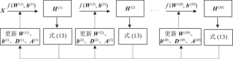
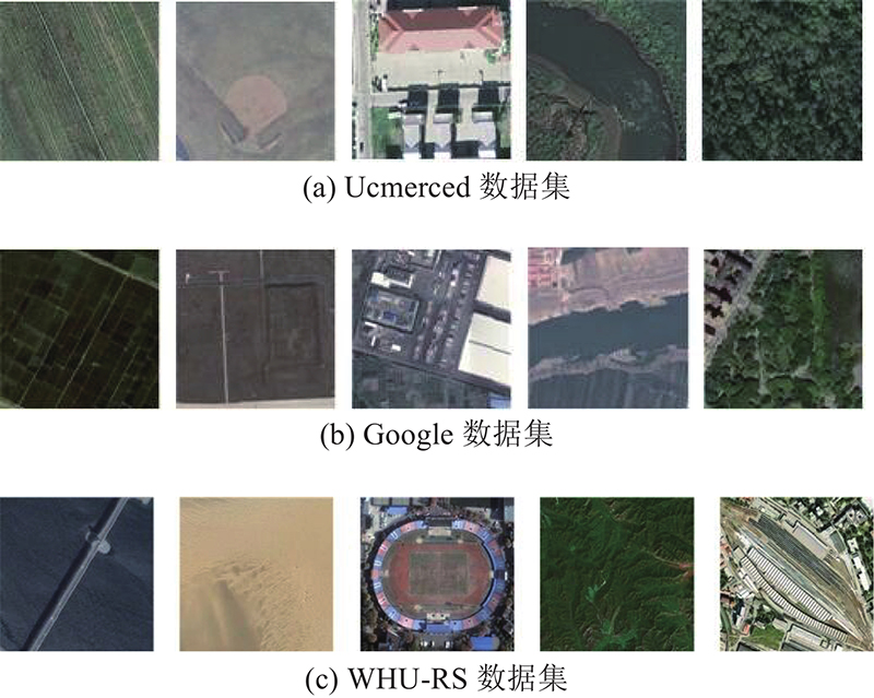
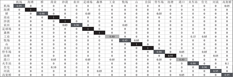
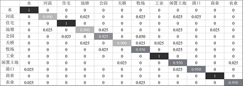
Abstract A hierarchical nonlinear subspace dictionary learning (HNSDL) method was proposed to improve the accuracy of remote sensing image scene classification. HNSDL trained a multi-layer network model to learn a series of hierarchical nonlinear transformations. The remote sensing images were projected into a series of subspaces, and the local information preserved terms of sparse coding and projection coding were constructed in the subspaces. By preserving the local structure information, the intra-class difference of samples was minimized, and the classification and recognition ability was enhanced. To solve the joint learning task of subspace and dictionary, the alternating optimization algorithm was adopted the objective solution of HNSDL, so that the optimal solution of all parameters were obtained at the same time. Extensive experiments results which were designed and tested on the Ucmerced, Google and WHU-RS data sets showed that the proposed method had high classification accuracy in a variety of scene classifications of remote sensing images.
|
|
Received: 27 July 2021
Published: 30 June 2022
|
|
|
| Fund: 国家自然科学基金资助项目(61806026); 江苏省教育厅未来网络科研基金资助项目(FNSRFP-2021-YB-36); 常州市科技支撑社会发展资助项目 (CE20215032); 江苏省高职院校教师专业带头人高端研修资助项目(2020GRGDYX059) |
层次型非线性子空间字典学习
为了提高遥感图像场景分类的准确率,提出层次型非线性子空间字典学习(HNSDL)方法. 用所提方法训练多层网络模型学习多层非线性变换. 将遥感图像投影到子空间中,构建稀疏编码和投影编码的局部信息保持项,在保持局部结构信息的同时最小化样本的类内差异,增强模型的分类识别能力. 在模型目标式求解中,使用交替学习算法求解子空间和字典的联合学习任务,使所有参数同时达到最优解. 在Ucmerced、Google和WHU-RS数据集上进行实验设计和测试,结果表明所提方法在遥感图像的多种场景分类上均表现出较高的分类准确率.
关键词:
遥感图像分类,
稀疏表示,
子空间学习,
字典学习
|
|
| [1] |
CHENG G, XIE X, HAN J, et al Remote sensing image scene classification meets deep learning: challenges, methods, benchmarks, and opportunities[J]. IEEE Journal of Selected Topics in Applied Earth Observations and Remote Sensing, 2020, 13: 3735- 3756
doi: 10.1109/JSTARS.2020.3005403
|
|
|
| [2] |
XU K, HUANG H, DENG P, et al Two-stream feature aggregation deep neural network for scene classification of remote sensing images[J]. Information Sciences, 2020, 539: 250- 268
doi: 10.1016/j.ins.2020.06.011
|
|
|
| [3] |
SHAWKY O A, HAGAG A, EL-DAHSHAN E, et al Remote sensing image scene classification using CNN-MLP with data augmentation[J]. Optik, 2020, 221: 165356
doi: 10.1016/j.ijleo.2020.165356
|
|
|
| [4] |
高雪艳, 潘安宁, 杨扬 基于图像混合特征的城市绿地遥感图像配准[J]. 浙江大学学报: 工学版, 2019, 53 (6): 1205- 1217
GAO Xue-yan, PAN An-ning, YANG Yang Urban green space remote sensing image registration using image mixed features[J]. Journal of Zhejiang University: Engineering Science, 2019, 53 (6): 1205- 1217
|
|
|
| [5] |
王昶, 张永生, 王旭, 等 基于深度学习的遥感影像变化检测方法[J]. 浙江大学学报: 工学版, 2020, 54 (11): 2138- 2148
WANG Xu, ZHANG Yong-sheng, WANG Xu, et al Remote sensing image change detection method based on deep neural networks[J]. Journal of Zhejiang University: Engineering Science, 2020, 54 (11): 2138- 2148
|
|
|
| [6] |
RAZAQUE A, BEN HAJ FREJ M, ALMI'ANI M, et al Improved support vector machine enabled radial basis function and linear variants for remote sensing image classification[J]. Sensors, 2021, 21 (13): 4431
doi: 10.3390/s21134431
|
|
|
| [7] |
PASTORINO M, MONTALDO A, FRONDA L, et al Multisensor and multiresolution remote sensing image classification through a causal hierarchical Markov framework and decision tree ensembles[J]. Remote Sensing, 2021, 13 (5): 849
doi: 10.3390/rs13050849
|
|
|
| [8] |
PAN H, JIA Y, ZHAO D, et al A tidal flat wetlands delineation and classification method for high-resolution imagery[J]. International Journal of Geo-Information, 2021, 10 (7): 451
doi: 10.3390/ijgi10070451
|
|
|
| [9] |
YU D, XU Q, GUO H, et al An efficient and lightweight convolutional neural network for remote sensing image scene classification[J]. Sensors, 2020, 20 (7): 1999
doi: 10.3390/s20071999
|
|
|
| [10] |
YANG X, YAN W, NI W, et al Object-guided remote sensing image scene classification based on joint use of deep-learning classifier and detector[J]. IEEE Journal of Selected Topics in Applied Earth Observations and Remote Sensing, 2020, 13: 2673- 2684
doi: 10.1109/JSTARS.2020.2996760
|
|
|
| [11] |
王协, 章孝灿, 苏程 基于多尺度学习与深度卷积神经网络的遥感图像土地利用分类[J]. 浙江大学学报: 理学版, 2020, 47 (6): 715- 723
WANG Xie, ZHANG Xiao-can, SU Cheng Land use classification of remote sensing images based on multi-scale learning and deep convolution neural network[J]. Journal of Zhejiang University: Science Edition, 2020, 47 (6): 715- 723
|
|
|
| [12] |
CHENG G, ZHOU P, HAN J, et al Auto-encoder-based shared mid-level visual dictionary learning for scene classification using very high resolution remote sensing images[J]. IET Computer Vision, 2015, 9 (5): 639- 647
doi: 10.1049/iet-cvi.2014.0270
|
|
|
| [13] |
HUANG Z, CHEN H X, ZHOU T, et al Contrast-weighted dictionary learning based saliency detection for remote sensing images[J]. Pattern Recognition, 2021, 113: 107757
doi: 10.1016/j.patcog.2020.107757
|
|
|
| [14] |
XU M, JIA X, PICKERING M, et al Cloud removal based on sparse representation via multitemporal dictionary learning[J]. IEEE Transactions on Geoscience and Remote Sensing, 2016, 54 (5): 2998- 3006
doi: 10.1109/TGRS.2015.2509860
|
|
|
| [15] |
FERRARIS V, DOBIGEON N, CAVALCANTI Y, et al Coupled dictionary learning for unsupervised change detection between multimodal remote sensing images[J]. Computer Vision and Image Understanding, 2019, 189: 102817
doi: 10.1016/j.cviu.2019.102817
|
|
|
| [16] |
WANG L, GENG H, LIU P, et al Particle swarm optimization based dictionary learning for remote sensing big data[J]. Knowledge-Based Systems, 2015, 79: 43- 50
doi: 10.1016/j.knosys.2014.10.004
|
|
|
| [17] |
WANG X, WANG S, LI Y, et al Hyperspectral image sparse reconstruction model based on collaborative multidimensional correlation[J]. Applied Soft Computing, 2021, 105: 107250
doi: 10.1016/j.asoc.2021.107250
|
|
|
| [18] |
YANKELEVSKY Y, ELAD M Finding GEMS: multi-scale dictionaries for high-dimensional graph signals[J]. IEEE Transactions on Signal Processing, 2019, 67 (7): 1889- 1901
doi: 10.1109/TSP.2019.2899822
|
|
|
| [19] |
WANG A, LU J, CAI J, et al Unsupervised joint feature learning and encoding for RGB-D scene labeling[J]. IEEE Transactions on Image Processing, 2015, 24 (11): 4459- 4473
doi: 10.1109/TIP.2015.2465133
|
|
|
| [20] |
LIU F, MA J, WANG Q Atom-substituted tensor dictionary learning enhanced convolutional neural network for hyperspectral image classification[J]. Neurocomputing, 2021, 455: 215- 228
doi: 10.1016/j.neucom.2021.05.051
|
|
|
| [21] |
DONOHO D L, HUO X Uncertainty principles and ideal atomic decomposition[J]. IEEE Transactions on Information Theory, 2001, 47 (7): 2845- 2862
doi: 10.1109/18.959265
|
|
|
| [22] |
SINGHALV, AGGARWAL H K, TARIYAL S, et al Discriminative robust deep dictionary learning for hyperspectral image classification[J]. IEEE Transactions on Geoscience and Remote Sensing, 2017, 55 (9): 5274- 5283
doi: 10.1109/TGRS.2017.2704590
|
|
|
| [23] |
LI Z, LAI Z, YONG X, et al A locality-constrained and label embedding dictionary learning algorithm for image classification[J]. IEEE Transactions on Neural Networks and Learning Systems, 2017, 28 (2): 278- 293
doi: 10.1109/TNNLS.2015.2508025
|
|
|
| [24] |
PENG Y, LIU S, WANG X, et al Joint local constraint and fisher discrimination based dictionary learning for image classification[J]. Neurocomputing, 2020, 398: 505- 519
doi: 10.1016/j.neucom.2019.05.103
|
|
|
| [25] |
AHARON M, ELAD M, BRUCKSTERIN A K-SVD: an algorithm for designing overcomplete dictionaries for sparse representation[J]. IEEE Transactions on Signal Processing, 2006, 54 (11): 4311- 4322
doi: 10.1109/TSP.2006.881199
|
|
|
| [26] |
YANG Y, NEWSAM S. Bag-of-visual-words and spatial extensions for land-use classification [C]// Proceedings of 18th SIGSPATIAL International Conference on Advances in Geographic Information Systems. San Jose: ACM, 2010: 270-279.
|
|
|
| [27] |
ZHU Q, ZHONG Y, ZHAO B, et al Bag-of-visual-words scene classifier with local and global features for high spatial resolution remote sensing imagery[J]. IEEE Geoscience and Remote Sensing Letters, 2016, 13 (6): 747- 751
doi: 10.1109/LGRS.2015.2513443
|
|
|
| [28] |
XIA G S, YANG W, DELON J, et al. Structrual high-resolution satellite image indexing [C]// Proceeding of the ISPRS, TC VII Symposium: 100 Years ISPRS. Vienna: ISPRS, 2010: 298–303.
|
|
|
| [29] |
JIA Y, SHELHAMER E, DONAHUE J, et al. Caffe: convolutional architecture for fast feature embedding [C]// Proceedings of the 22nd ACM International Conference on Multimedia. Utrecht: ACM, 2014: 675-678.
|
|
|
| [30] |
WEN J, TIAN Z, SHE H. Feature extraction of hyperspectral images based on preserving neighborhood discriminant embedding [C]// 2010 International Conference on Image Analysis and Signal Processing. Yantai: IEEE, 2010: 257-262.
|
|
|
| [31] |
QAYYUM A, SAEED MALIK A, SAAD N M. et al. Image classification based on sparse-coded features using sparse coding technique for aerial imagery: a hybrid dictionary approach [J]. Neural Computation and Application. 2019, 31: 3587-3607.
|
|
|
| [32] |
KRIZHEVSKY A, SUTSKEVER I, HINTON G E. ImageNet classification with deep convolutional neural networks [C]// Proceedings of 26th Annual Conference on Neural Information Processing Systems. Lake Tahoe: MIT Press, 2012: 1097-1105.
|
|
|
| [33] |
YU Y, LIU F A two-stream deep fusion framework for high-resolution aerial scene classification[J]. Computational Intelligence and Neuroscience, 2018, 2018: 8639367
|
|
|
| [34] |
ROMERO A, GATTA C, CAMPS-VALLS G Unsupervised deep feature extraction for remote sensing image classification[J]. IEEE Transactions on Geoscience and Remote Sensing, 2016, 54 (3): 1349- 1362
doi: 10.1109/TGRS.2015.2478379
|
|
|
|
Viewed |
|
|
|
Full text
|
|
|
|
|
Abstract
|
|
|
|
|
Cited |
|
|
|
|
| |
Shared |
|
|
|
|
| |
Discussed |
|
|
|
|