|
|
|
| Multi-scale urban spatial pattern recognition based on skeleton line |
Haoran SONG1,2,3( ),Xiaomin LU1,2,3,*(),Zhiyi ZHANG1,2,3,Haowen YAN1,2,3,Chi ZOU1,2,3 ),Xiaomin LU1,2,3,*(),Zhiyi ZHANG1,2,3,Haowen YAN1,2,3,Chi ZOU1,2,3 |
1. Faculty of Geomatics, Lanzhou Jiaotong University, Lanzhou 730070, China
2. National-Local Joint Engineering Research Center of Technologies and Applications for National Geographic State Monitoring, Lanzhou 730070, China
3. Key Laboratory of Science and Technology in Surveying and Mapping, Gansu Province, Lanzhou 730070, China |
|
|
|
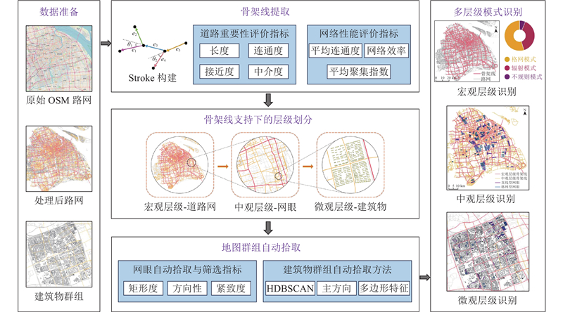
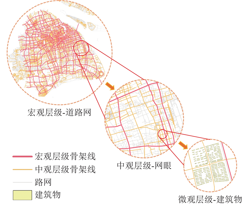
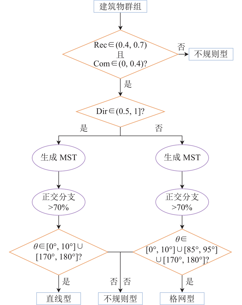
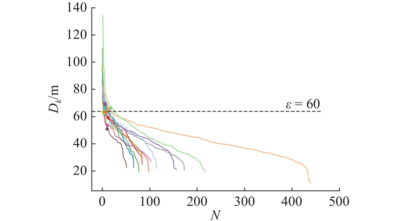
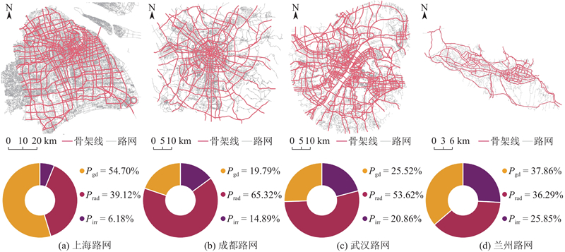
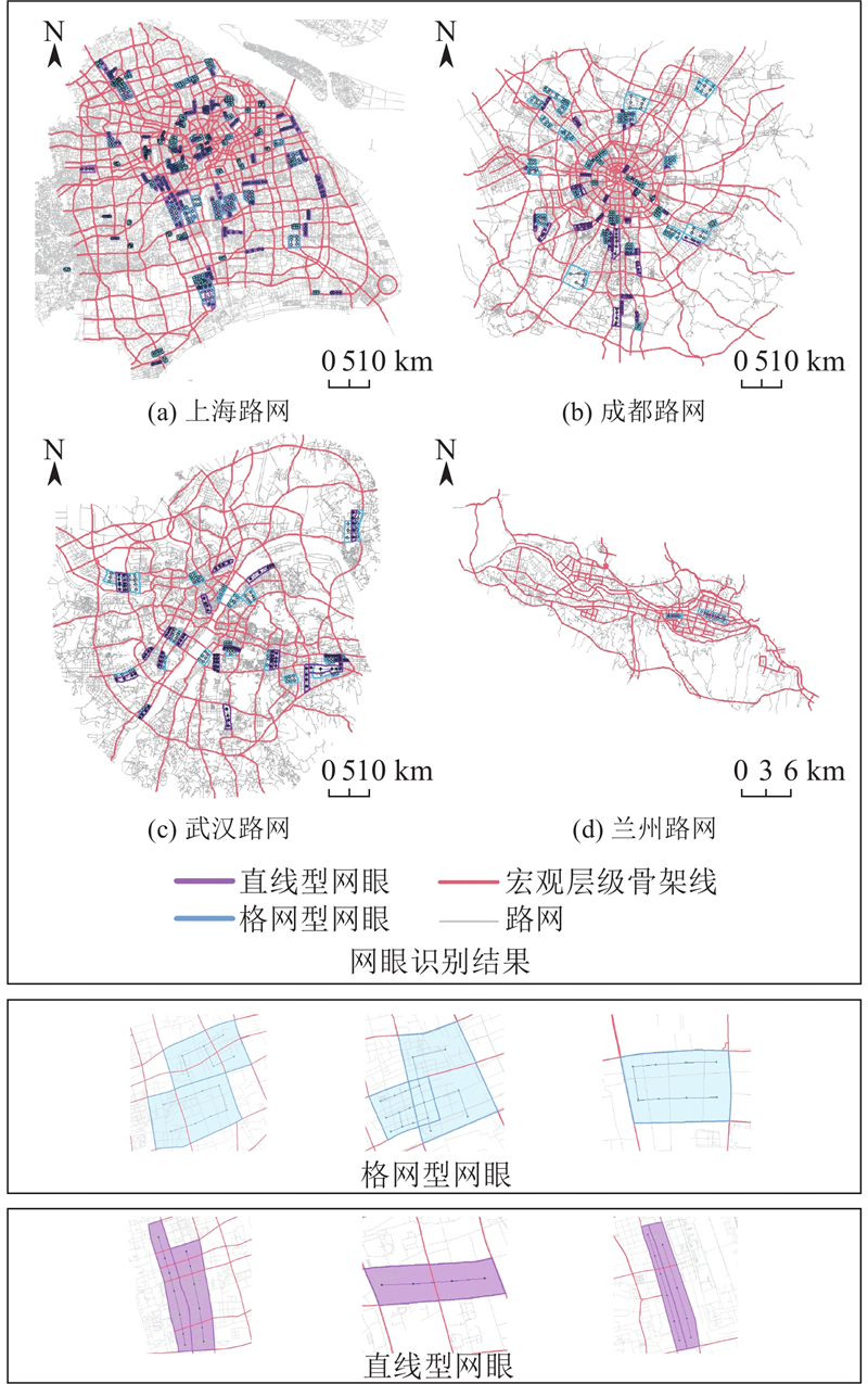
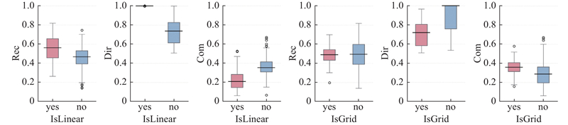
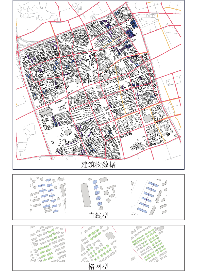
Abstract A multi-level urban spatial pattern recognition method based on road network skeleton line was proposed to reveal urban hierarchy and complexity in order to address the limitation where existing research on road network and building group was often confined to single-level analysis. A road network evaluation system was constructed by integrating space syntax and fractal geometry in order to extract macroscopic skeleton lines and analyze their topology. Road mesh was automatically extracted via morphological quantification and adjacency analysis. Spatial pattern of road mesh was identified by using the minimum spanning tree (MST) algorithm. Building was partitioned based on mesoscopic skeleton line. Automatic extraction and pattern recognition of building group were achieved by using hierarchical density-based spatial clustering of application with noise (HDBSCAN), Prim’s MST algorithm and the C4.5 decision tree. Validations in Shanghai, Chengdu, Wuhan and Lanzhou demonstrated the effectiveness of the method. The method can be used to efficiently and accurately identify urban spatial pattern across different levels.
|
|
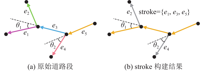
Received: 10 July 2025
Published: 06 May 2026
|
|
|
| Fund: 国家自然科学基金资助项目(42161066, 42471476);甘肃省自然科学基金资助项目(24JRRA224). |
|
Corresponding Authors:
Xiaomin LU
E-mail: songhaoran0533@163.com;xiaominlu08@mail.lzjtu.cn
|
基于骨架线的多层级城市空间模式识别
针对现有研究在分析道路网与建筑物群组几何拓扑特征时多局限于单一层级识别的局限性,提出基于道路网骨架线的多层级城市空间分布模式识别方法,旨在揭示城市空间的层次性与复杂性. 整合空间句法和分形几何理论,构建道路网评价体系,提取宏观骨架线并分析拓扑结构. 通过形态量化和邻接关系分析,自动提取道路网眼,利用最小生成树(MST)算法识别网眼的空间模式. 基于中观骨架线划分建筑物,结合基于层次密度的噪声应用空间聚类(HDBSCAN)、Prim最小生成树算法及C4.5决策树,实现建筑物群组的自动提取与模式识别. 以上海、成都、武汉、兰州为实验区,验证了该方法的有效性. 结果表明,采用该方法,能够高效、准确地识别不同层级下的城市空间分布模式.
关键词:
多尺度道路网,
建筑物群组,
模式识别,
地图综合,
最小生成树(MST)
|
|
| [1] |
JIANG B, CLARAMUNT C A structural approach to the model generalization of an urban street network[J]. GeoInformatica, 2004, 8 (2): 157- 171
doi: 10.1023/B:GEIN.0000017746.44824.70
|
|
|
| [2] |
GUO X, LIU J, WU F, et al A method for intelligent road network selection based on graph neural network[J]. ISPRS International Journal of Geo-Information, 2023, 12 (8): 336
doi: 10.3390/ijgi12080336
|
|
|
| [3] |
焦利民, 李泽慧, 许刚, 等 武汉市城市空间集聚要素的分布特征与模式[J]. 地理学报, 2017, 72 (8): 1432- 1443
JIAO Limin, LI Zehui, XU Gang, et al The characteristics and patterns of spatially aggregated elements in urban areas of Wuhan[J]. Acta Geographica Sinica, 2017, 72 (8): 1432- 1443
|
|
|
| [4] |
JIANG B, HARRIE L Selection of streets from a network using self-organizing maps[J]. Transactions in GIS, 2004, 8 (3): 335- 350
doi: 10.1111/j.1467-9671.2004.00186.x
|
|
|
| [5] |
HAN Y, WANG Z, LU X, et al Application of AHP to road selection[J]. ISPRS International Journal of Geo-Information, 2020, 9 (2): 86
doi: 10.3390/ijgi9020086
|
|
|
| [6] |
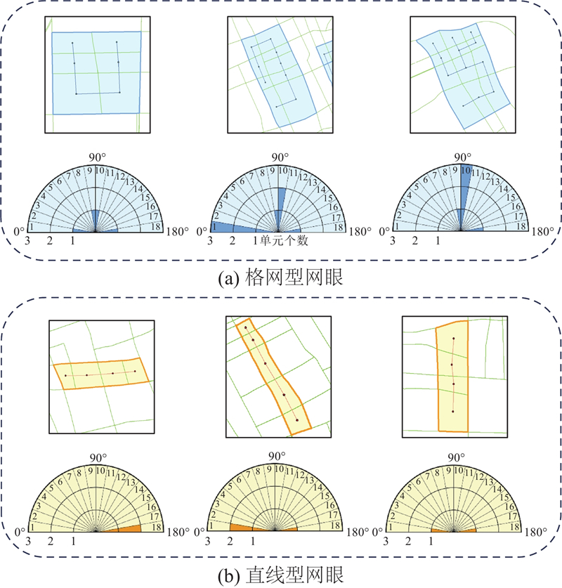
田晶, 艾廷华, 丁绍军 基于C4.5算法的道路网网格模式识别[J]. 测绘学报, 2012, 41 (1): 121- 126
TIAN Jing, AI Tinghua, DING Shaojun Grid pattern recognition in road networks based on C4.5 algorithm[J]. Acta Geodaetica et Cartographica Sinica, 2012, 41 (1): 121- 126
|
|
|
| [7] |
王安东, 武芳, 巩现勇, 等 一种城市路网多层次复合网格模式识别方法[J]. 测绘学报, 2023, 52 (11): 1994- 2006
WANG Andong, WU Fang, GONG Xianyong, et al A recognition approach for compound grid pattern of urban road networks[J]. Acta Geodaetica et Cartographica Sinica, 2023, 52 (11): 1994- 2006
doi: 10.11947/j.AGCS.2023.20220528
|
|
|
| [8] |
巩现勇. 城市建筑群典型空间分布模式的识别方法研究 [D]. 郑州: 解放军信息工程大学, 2014.
GONG Xianyong. Research on typical map pattern recognition in Urban building groups [D]. Zhengzhou: The PLA Information Engineering University, 2014.
|
|
|
| [9] |
WEI Z, DING S, CHENG L, et al Linear building pattern recognition in topographical maps combining convex polygon decomposition[J]. Geocarto International, 2022, 37 (26): 11365- 11389
doi: 10.1080/10106049.2022.2055794
|
|
|
| [10] |
MA W, WANG B, LIU C, et al Complex buildings orientation recognition and description based on vector reconstruction[J]. International Journal of Applied Earth Observation and Geoinformation, 2023, 123: 103486
doi: 10.1016/j.jag.2023.103486
|
|
|
| [11] |
HEINZLE F, ANDERS K H. Characterising space via pattern recognition techniques [M]//Generalisation of Geographic Information. Amsterdam: Elsevier, 2007: 233–253.
|
|
|
| [12] |
WANG X, YOU S, WANG L Classifying road network patterns using multinomial logit model[J]. Journal of Transport Geography, 2017, 58: 104- 112
doi: 10.1016/j.jtrangeo.2016.11.013
|
|
|
| [13] |
高晓蓉, 闫浩文, 禄小敏 多尺度地图空间居民地语义相似度计算方法[J]. 测绘学报, 2022, 51 (1): 95- 103
GAO Xiaorong, YAN Haowen, LU Xiaomin Semantic similarity measurement for building polygon aggregation in multi-scale map space[J]. Acta Geodaetica et Cartographica Sinica, 2022, 51 (1): 95- 103
|
|
|
| [14] |
YANG B, LUAN X, LI Q Generating hierarchical strokes from urban street networks based on spatial pattern recognition[J]. International Journal of Geographical Information Science, 2011, 25 (12): 2025- 2050
doi: 10.1080/13658816.2011.570270
|
|
|
| [15] |
ZHOU Q, LI Z A comparative study of various strategies to concatenate road segments into strokes for map generalization[J]. International Journal of Geographical Information Science, 2012, 26 (4): 691- 715
doi: 10.1080/13658816.2011.609990
|
|
|
| [16] |
WEI Z, XU W, XIAO Y, et al Enhancing building pattern recognition through multi-scale data and knowledge graph: a case study of C-shaped patterns[J]. International Journal of Digital Earth, 2023, 16 (1): 3860- 3881
doi: 10.1080/17538947.2023.2259868
|
|
|
| [17] |
THOMSON R C, RICHARDSON D E. The ‘good continuation’ principle of perceptual organization applied to the generalization of road networks [C]// Proceedings of the ICA 19th International Cartographic Conference. Ottawa: [s. n. ], 1999: 1215-1223.
|
|
|
| [18] |
ZHOU Q, LI Z. Evaluation of properties to determine the importance of individual roads for map generalization [M]//Advances in Cartography and GIScience. Volume 1. Berlin: Springer, 2011: 459–475.
|
|
|
| [19] |
PILEHFOROOSHHA P, KARIMI M A local adaptive density-based algorithm for clustering polygonal buildings in urban block polygons[J]. Geocarto International, 2020, 35 (2): 141- 167
doi: 10.1080/10106049.2018.1508313
|
|
|
| [20] |
孟妮娜, 王正阳, 高晨博, 等 一种融合局部异常因子的矢量建筑物群聚类方法[J]. 武汉大学学报: 信息科学版, 2024, 49 (4): 562- 571
MENG Nina, WANG Zhengyang, GAO Chenbo, et al A vector building clustering algorithm based on local outlier factor[J]. Geomatics and Information Science of Wuhan University, 2024, 49 (4): 562- 571
doi: 10.13203/j.whugis20220688
|
|
|
|
Viewed |
|
|
|
Full text
|
|
|
|
|
Abstract
|
|
|
|
|
Cited |
|
|
|
|
| |
Shared |
|
|
|
|
| |
Discussed |
|
|
|
|