1. Ocean College, Zhejiang University, Zhoushan 316012, China 2. Key Laboratory of Marine Geotechnical Engineering and Materials of Zhejiang Province, Hangzhou 310058, China 3. Shanghai Typhoon Research Institute, China Meteorology Administration, Shanghai 200030, China 4. Shanghai Marine Meteorological Observatory, Shanghai 200030, China
The finite-volume community ocean model (FVCOM) was used to establish a high-resolution numerical model based on the latest bathymetry data and unstructured mesh. The three-dimensional characteristics of the tidal current and residual current in Yangshan Harbor after the construction of the harbor were studied. Model results indicated that the speed of flood tide was faster than that of the ebb tide in the west of the narrow, and the performance of the east was opposite. The speed in the south of the islands was higher than that in the north. High velocity region and circulation phenomenon appeared at the narrow entrance of the tidal channel, and the peak speed reached 2.88 m/s at the surface level during flood tide. In the north and south areas of the islands, eddies were formed during the flood slack tide, with the northward current at surface and southward current at bottom. And the direction was opposite during ebb slack tide. A circulation existed with the southward current at surface and northward current at bottom during ebb tide at the deep-water channel. The directions of the M2 tidal ellipses were controlled by the coastlines under the influence of the project. The tidal choking effect increased after the construction of the harbor. The residual current was dominated by seaward in Yangshan Harbor sea area, but landward residual current existed in the channel. Separation of residual current appeared at the narrow entrance of the tidal channel. The stagnation point moved eastward.
Yan-ling TANG,Lu-di XU,Zhi-guo HE,Bao-de CHEN,Jie XU,Li LI. Numerical simulation of three-dimensional characteristics of tidal current and residual current in Yangshan Harbor. Journal of ZheJiang University (Engineering Science), 2019, 53(2): 315-324.
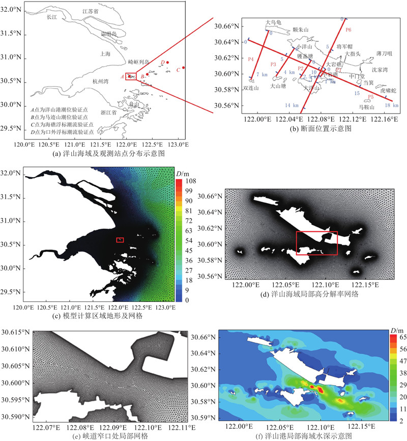
Fig.1Sketch of location of computational domain, model mesh and terrain
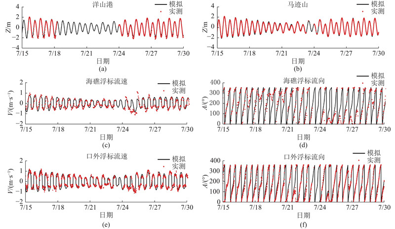
Fig.2Verification of tidal elevation in Yangshan Harbor and Majishan, and verification of flow velocity and flow direction in Haijiaofubiao and Kouwaifubiao
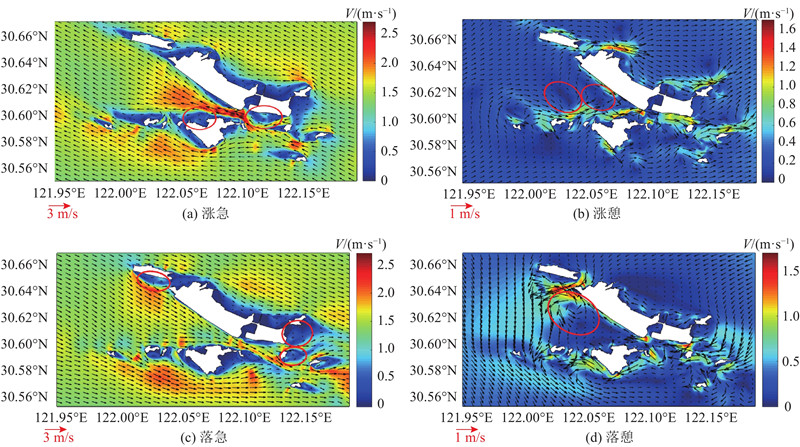
Fig.3Surface flow field in each period during spring tide in Yangshan Harbor with red circle representing circulation position in each period
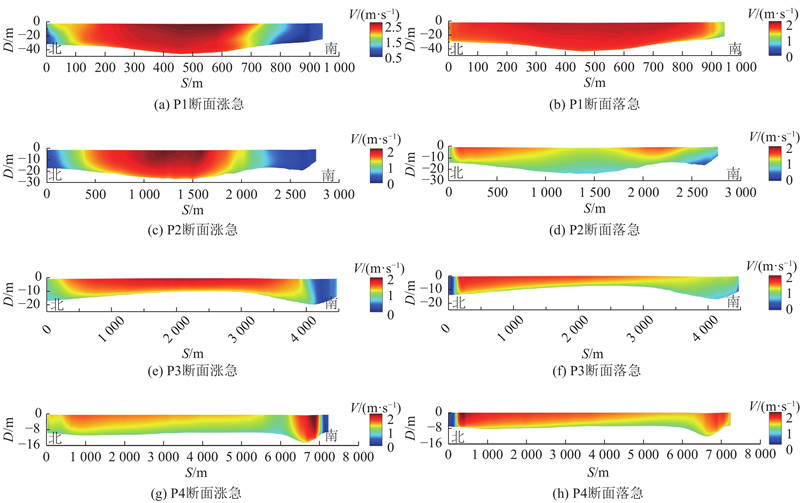
Fig.4Vertical velocity profile in P1 to P4 cross sections in flood and ebb periods during spring tide
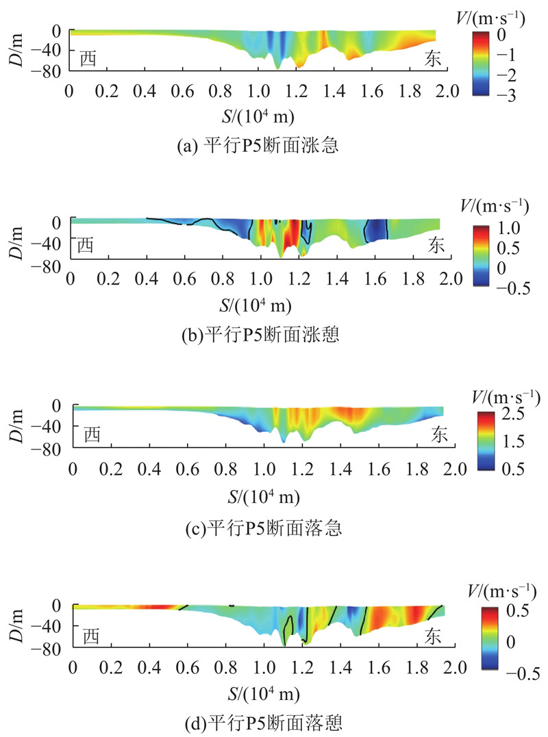
Fig.5Vertical velocity profile parallel to P5 cross section in flood and ebb periods during spring tide with black line representing contour of 0 flow rate
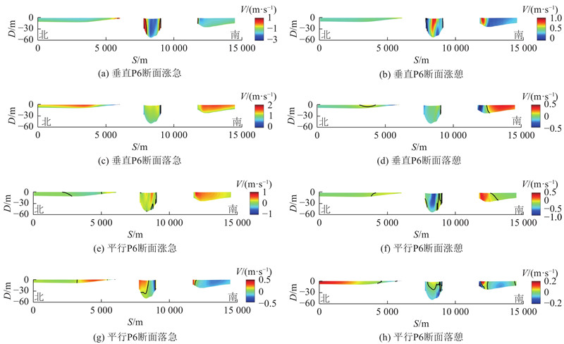
Fig.6Vertical velocity profiles parallel or perpendicular to P5 cross section respectively in flood and ebb periods during spring tide with black line representing contour of 0 flow rate
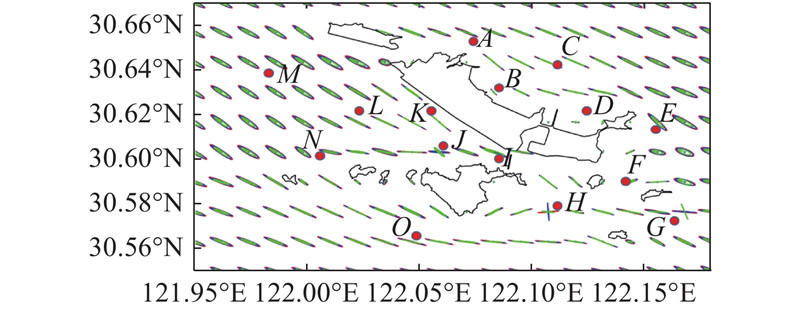
Fig.7Distribution of tidal current ellipses in Yangshan Harbor with red lines representing surface layer, blue lines representing middle layer, and green lines representing bottom layer
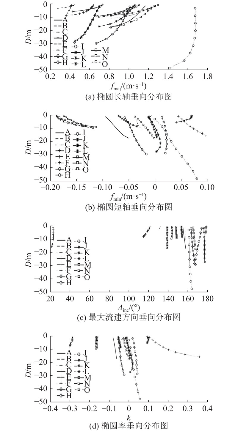
Fig.8Vertical distribution of semimajor, semiminor, inclination and ellipticity of M2 tidal current ellipse
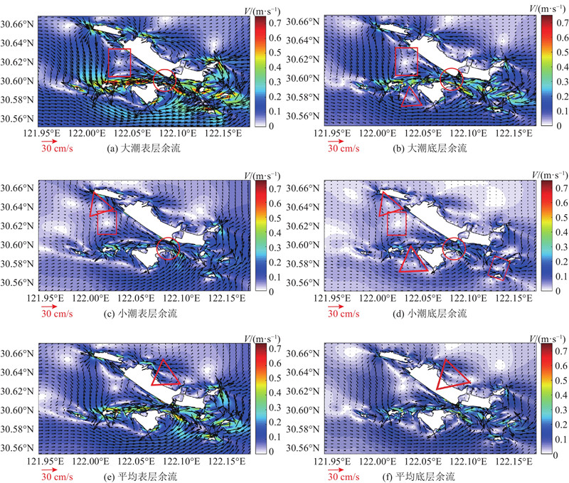
Fig.9Distribution of Euler residual current with red rectangle, circle, and triangle representing stagnation point, separation point and circulation position respectively
[1]
GUO W Y, WANG X H, DING P X, et al A system shift in tidal choking due to the construction of Yangshan Harbour, Shanghai, China[J]. Estuarine, Coastal and Shelf Science, 2017, 206 (30): 49- 60
[2]
陈沈良 崎岖列岛海区的水文泥沙及其峡道效应[J]. 海洋学报, 2000, 22 (3): 123- 131 CHEN Shen-liang Hydrodynamics, sediments and strait-channel effects for the Qiqu Archipelago[J]. Acta Oceanologica Sinica, 2000, 22 (3): 123- 131
doi: 10.3321/j.issn:0253-4193.2000.03.017
[3]
CHEN X E, ZHAN P, CHEN J R, et al Numerical study of current fields near the Changjiang Estuary and impact of Quick-EnKF Assimilation[J]. Acta Oceanologica Sinica, 2011, 30 (5): 33- 44
doi: 10.1007/s13131-011-0145-0
[4]
李玉中, 陈沈良. 洋山港海域与长江口相似性研究[J]. 地理学报, 2002(06): 662–670. LI Yu-zhong, CHEN Shen-liang. Similarities between Yangshan Harbor sea area and the Yangtze Estuary[J]. Acta Geographica Sinica, 2002(6): 662–670.
[5]
李玉中, 陈沈良 洋山港海域余流分离和会聚现象研究[J]. 水利学报, 2003, (5): 24- 29 LI Yu-zhong, CHEN Shen-liang Separation and convergence of residual flows in Yangshan Harbor area[J]. Journal of Hydraulic Engineering, 2003, (5): 24- 29
doi: 10.3321/j.issn:0559-9350.2003.05.004
[6]
YING X, DING P, WANG Z B, et al Morphological impact of the construction of an offshore Yangshan deepwater Harbor in the port of Shanghai, China[J]. Journal of Coastal Research, 2011, 28 (1A): 163- 173
[7]
杜景龙, 杨世伦, 贺松林, 等 洋山港堵汊工程对邻近海底冲淤影响分析[J]. 海洋工程, 2008, (4): 53- 59 DU Jing-long, YANG Shi-lun, HE Song-lin, et al Primary analysis on the erosion-accretion change of the seabed around Yangshan Harbor before and after the plugging offshoot project[J]. The Ocean Engineering, 2008, (4): 53- 59
doi: 10.3969/j.issn.1005-9865.2008.04.009
[8]
万新宁. 洋山海域峡道效应对于工程的综合响应[D]. 上海: 华东师范大学, 2008: 13–56. WAN Xin-ning. Response of the strait-channel effects to Habor Project in the Yangshan sea area [D]. Shanghai: East China Normal University, 2008: 13–56.
[9]
ZUO S H, ZHANG N C, BEI L, et al Numerical simulation of tidal current and erosion and sedimentation in the Yangshan deep-water harbor of Shanghai[J]. International Journal of Sediment Research, 2009, 24 (3): 287- 298
doi: 10.1016/S1001-6279(10)60004-2
[10]
左书华, 李蓓, 杨华 洋山港建设时期海域通道冲淤变化特征分析[J]. 水道港口, 2009, (1): 14- 19 ZUO Shu-hua, LI Bei, YANG Hua Analysis on erosion and accretion characteristics in the channel during construction period of Yangshan Harbor[J]. Journal of Waterway and Harbor, 2009, (1): 14- 19
doi: 10.3969/j.issn.1005-8443.2009.01.003
[11]
张志林, 朱巧云, 陈建民, 等 崎岖列岛堵汊工程对洋山深水港区冲淤影响分析[J]. 长江科学院院报, 2010, 27 (12): 5- 16 ZHANG Zhi-lin, ZHU Qiao-yun, CHEN Jian-min, et al Influence of blocked bifurcations along Qiqu Archipelago on erosion and sedimentation of sea bed at Yangshan deepwater harbor[J]. Journal of Yangtze River Scientific Research Institute, 2010, 27 (12): 5- 16
doi: 10.3969/j.issn.1001-5485.2010.12.002
[12]
张志林, 朱巧云, 李身铎 长江口洋山港建设对附近海域潮动力影响研究[J]. 人民长江, 2013, 44 (5): 18- 22 ZHANG Zhi-lin, ZHU Qiao-yun, LI Shen-duo Study on influence of Yangshan Port construction in Yangtze River Estuary on tidal current in nearby area[J]. Yangtze River, 2013, 44 (5): 18- 22
doi: 10.3969/j.issn.1001-4179.2013.05.006
[13]
杨忠勇, 李娜, 虞志英, 等 洋山港区堵汊工程对海底地形影响初探[J]. 海洋通报, 2010, 29 (2): 166- 171 YANG Zhong-yong, LI Na, YU Zhi-ying, et al Preliminary research on the impact of blocking branch on the topography of seabed in Yangshan Port[J]. Marine Science Bulletin, 2010, 29 (2): 166- 171
doi: 10.3969/j.issn.1001-6392.2010.02.008
[14]
杨忠勇, 程和琴, 朱建荣, 等 洋山港海域潮动力特征及其对工程的响应[J]. 地理学报, 2012, 67 (9): 1282- 1290 YANG Zhong-yong, CHENG He-qin, ZHU Jian-rong, et al Tidal dynamics of Yangshan Harbor sea area and its response to the project[J]. Acta Geographica Sinica, 2012, 67 (9): 1282- 1290
[15]
杨忠勇, 石小涛, 吴泽艳, 等 洋山海域工程前后水动力特征分析[J]. 长江流域资源与环境, 2017, 26 (1): 82- 90 YANG Zhong-yong, SHI Xiao-tao, WU Ze-yan, et al Analysis of hydrodynamics in Yangshan sea area before and after the project[J]. Resources and Environment in the Yangtze Basin, 2017, 26 (1): 82- 90
doi: 10.11870/cjlyzyyhj201701010
[16]
CHEN C, LIU H, BEARDSLEY R C An unstructured grid, finite-volume, three-dimensional, primitive equations ocean model: application to coastal ocean and estuaries[J]. Journal of Atmospheric and Oceanic Technology, 2003, 20 (1): 159- 186
doi: 10.1175/1520-0426(2003)020<0159:AUGFVT>2.0.CO;2
[17]
陈长胜. 海洋生态系统动力学与模型[M]. 北京: 高等教育出版社, 2003: 6.
[18]
LI L, WANG X H, WILLIAMS D, et al Numerical study of the effects of mangrove areas and tidal flats on tides: a case study of Darwin Harbour, Australia[J]. Journal of Geophysical Research: Oceans, 2012, 117 (C06011): 1- 12
[19]
MELLOR G L, YAMADA T A hierarchy of turbulence closure models for planetary boundary layers[J]. Journal of the Atmospheric Sciences, 1974, 31 (7): 1791- 1806
doi: 10.1175/1520-0469(1974)031<1791:AHOTCM>2.0.CO;2
[20]
MELLOR G L, YAMADA T Development of a turbulence closure model for geophysical fluid problems[J]. Reviews of Geophysics, 1982, 20 (4): 851- 875
doi: 10.1029/RG020i004p00851
[21]
WIJESEKERA H W, ALLEN J S, NEWBERGER P A Modeling study of turbulent mixing over the continental shelf: comparison of turbulent closure schemes[J]. Journal of Geophysical Research: Oceans, 2003, 108 (3103): 1- 25
[22]
PAWLOWICZ R, BEARDSLEY B, LENTZ S Classical tidal harmonic analysis including error estimates in MATLAB using T_TIDE[J]. Computers and Geosciences, 2002, 28 (8): 929- 937
[23]
WILLMOTT C J On the validation of models[J]. Physical geography, 1981, 2 (2): 184- 194
doi: 10.1080/02723646.1981.10642213
SHI Mao-shun, LI Wei, LIU Hong-wei, LIN Yong-gang, XU Quan-kun. Tidal current power management system with MPPT [J]. Journal of ZheJiang University (Engineering Science), 2013, 47(5): 750-754.