|
|
|
| Remote sensing image change detection method based on deep neural networks |
Chang WANG1,2( ),Yong-sheng ZHANG1,*(),Xu WANG3,Ying YU1 ),Yong-sheng ZHANG1,*(),Xu WANG3,Ying YU1 |
1. School of Geospatial Information, PLA Strategic Support Force Information Engineering University, Zhengzhou 450001, China
2. School of Civil Engineering, University of Science and Technology Liaoning, Anshan 114051, China
3. Surveying and Mapping Engineering Institute, Liaoning Vocational College of Ecological Engineering, Shenyang 110101, China |
|
|
|
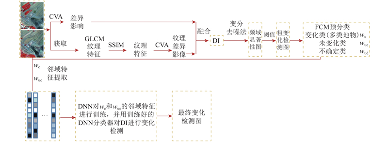
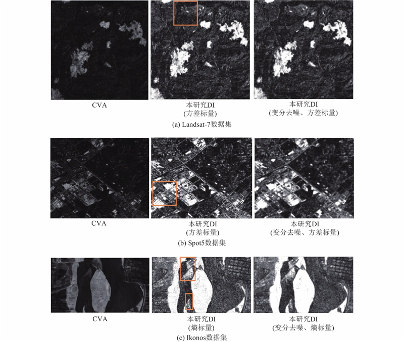
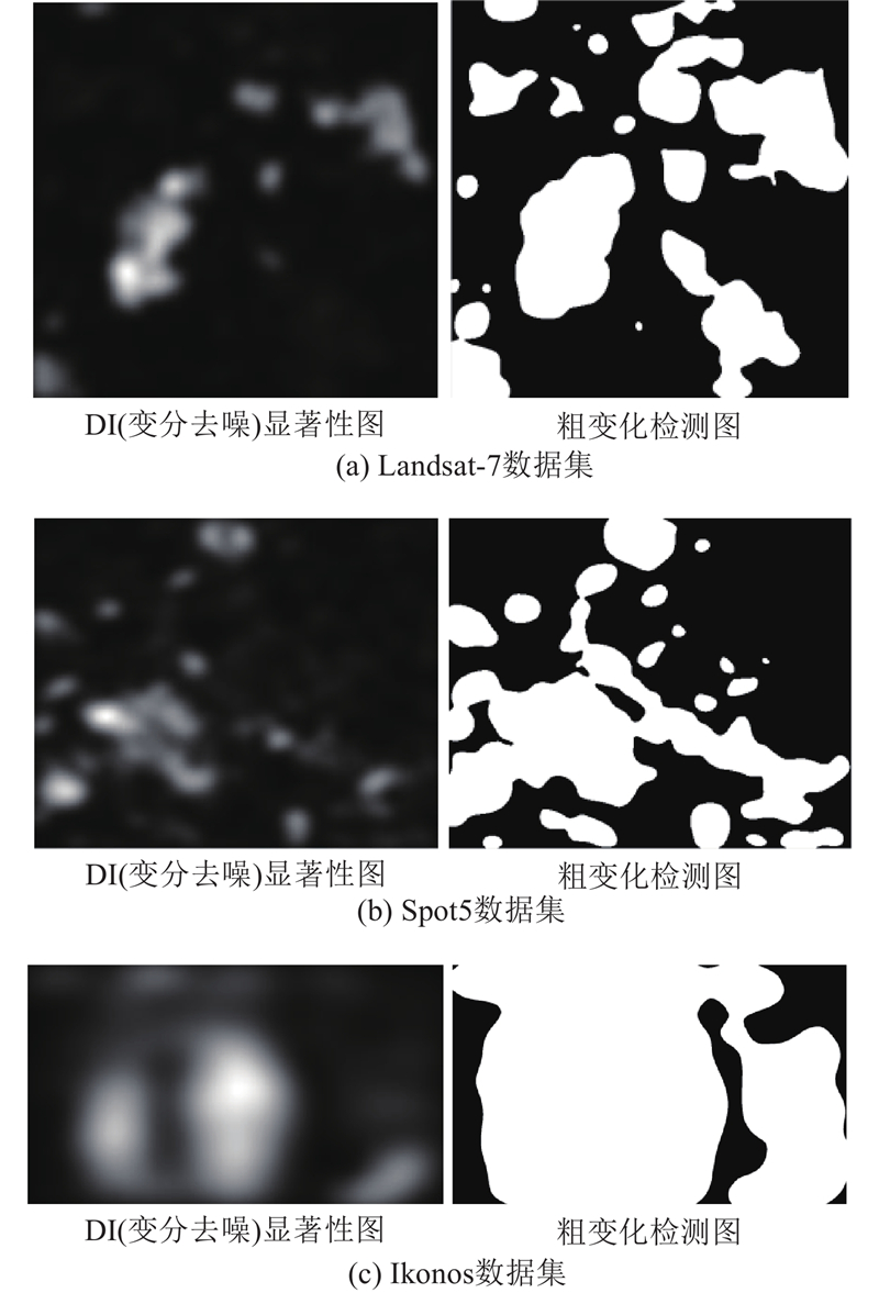
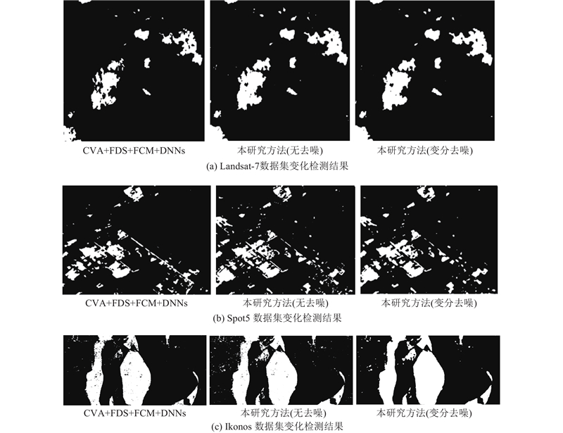
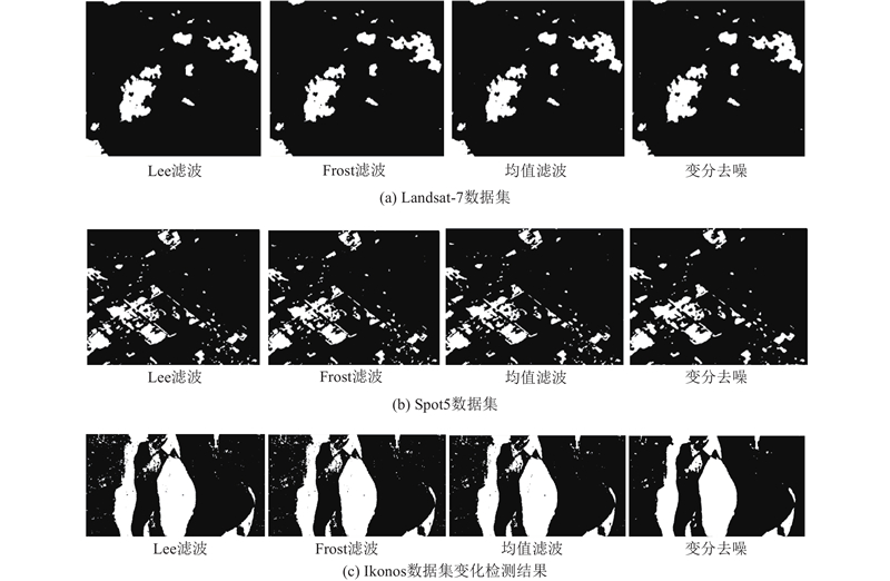
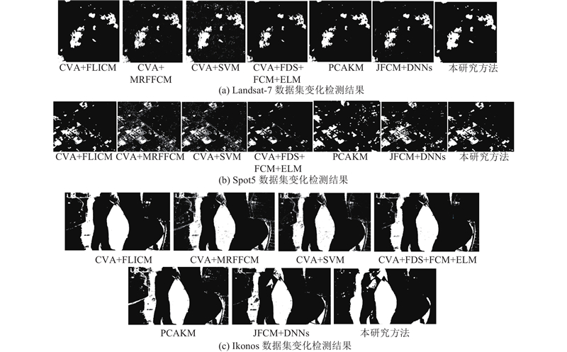
Abstract A remote sensing image change detection method based on deep learning was proposed to obtain reliable training samples and improve the accuracy of remote sensing image change detection. Firstly, texture features (gray co-occurrence matrix method) are selected by structural similarity method (SSIM), and the multitemporal remote sensing image difference image (DI) and textural feature DI obtained by change vector analysis (CVA) are fused to construct the final DI, then the difference images are denoised by the constructed variational denoising model. Secondly, the frequency domain significance method is used to obtain the DI saliency map, and the coarse change detection map obtained by selecting a threshold for the DI saliency map is pre-classified (change, unchanged and undetermined) by the fuzzy c-means (FCM) clustering algorithm. Finally, the neighborhood features of the changed pixels and unchanged pixels extracted from remote sensing images are introduced into the deep neural network model for training, and the trained deep neural network model is used to detect the changes in multitemporal remote sensing image, then the final change detection map is obtained. Experiment on three real remote sensing image data sets shows that the change detection accuracy of the proposed method is higher than that of other comparison methods.
|
|
Received: 18 September 2019
Published: 15 December 2020
|
|
|
|
Corresponding Authors:
Yong-sheng ZHANG
E-mail: wangchang324@163.com;yszhang2001@vip.163.com
|
基于深度学习的遥感影像变化检测方法
为了获得可靠的训练样本及提高遥感影像变化检测的精度,提出基于深度学习的遥感影像变化检测方法. 采用结构相似性方法(SSIM)选取纹理特征(灰度共生矩阵法),通过融合变化向量分析(CVA)方法获取不同时相遥感影像差异图(DI)及纹理特征差异图获得差异影像,并采用构造的变分去噪模型对差异影像进行去噪. 利用频域显著性方法获取去噪差异影像的显著性图,通过模糊c-均值(FCM)算法对粗变化检测图(对显著性图选取阈值获得的)进行预分类(变化类、未变化类及未确定类). 将从遥感影像上提取的变化像素和未变化像素的邻域特征引入深度神经网络模型进行训练,并利用训练好的深度神经网络模型对差异影像进行变化检测,得到最终的变化检测图. 对3组遥感影像数据集进行变化检测实验,结果表明本研究方法的变化检测精度高于其他比较方法.
关键词:
频域显著性方法,
变化向量分析,
灰度共生矩阵,
深度神经网络,
差异影像
|
|
| [1] |
HUSSAIN M, CHEN D, CHENG A Change detection from remotely sensed images: from pixel-based to object-based approaches[J]. ISPRS Journal of Photogrammetry and Remote Sensing, 2013, 80 (2): 91- 106
|
|
|
| [2] |
BOVOLO F, BRUZZONE L A theoretical framework for unsupervised change detection based on change vector analysis in the polar domain[J]. IEEE Transactions on Geoscience and Remote Sensing, 2007, 45 (1): 218- 236
doi: 10.1109/TGRS.2006.885408
|
|
|
| [3] |
ZHANG M, ZHAO Y Object-oriented and multi-feature hierarchical change detection based on CVA for high-resolution remote sensing imagery[J]. Journal of Remote Sensing, 2018, 22 (1): 119- 131
|
|
|
| [4] |
FENG W, ZHANG Y. Object-oriented change detection for remote sensing images based on multi-scale fusion [J]. Acta Geodaetica et Cartographica Sinica, 2015, 44(10): 1142-1151.
|
|
|
| [5] |
LI L, SHU N, WANG K Change detection method for remote sensing images based on multi-features fusion[J]. Acta Geodaetica et Cartogrphica Sinica, 2014, 43 (9): 945- 953
|
|
|
| [6] |
CELIK T Unsupervised change detection in satellite images using principal component analysis and k-means clustering[J]. IEEE Geoscience and Remote Sensing Letters, 2009, 6 (4): 772- 776
doi: 10.1109/LGRS.2009.2025059
|
|
|
| [7] |
MISHRA N S, GHOSH S, GHOSH A Fuzzy clustering algorithms incorporating local information for change detection in remotely sensed images[J]. Applied Soft Computing, 2012, 12 (8): 2683- 2692
doi: 10.1016/j.asoc.2012.03.060
|
|
|
| [8] |
STELIOS K, VASSILIOS C A robust fuzzy local information C-means clustering algorithm[J]. IEEE Transactions on Image Processing, 2010, 19 (5): 1328- 1337
doi: 10.1109/TIP.2010.2040763
|
|
|
| [9] |
GONG M, ZHOU Z, MA J Change detection in synthetic aperture radar images based on image fusion and fuzzy clustering[J]. IEEE Transactions on Image Processing, 2012, 21 (4): 2141- 2151
doi: 10.1109/TIP.2011.2170702
|
|
|
| [10] |
GAO F, DONG J, LI B. Change detection from synthetic aperture radar images based on neighborhood-based ratio and extreme learning machine[J]. Journal of Applied Remote Sensing, 2016, 10(4): 1-14.
|
|
|
| [11] |
TAN K, JIN X, PLAZA A Automatic change detection in high-resolution remote sensing images by using a multiple classifier system and spectral-spatial features[J]. IEEE Journal of Selected Topics in Applied Earth Observations and Remote Sensing, 2016, 9 (8): 3339- 3451
|
|
|
| [12] |
GONG M, ZHAO J, LIU J Change detection in synthetic aperture radar images based on deep neural networks[J]. IEEE Transactions on Neural Networks and Learning Systems, 2016, 27 (1): 125- 138
doi: 10.1109/TNNLS.2015.2435783
|
|
|
| [13] |
ZHANG X, CHEN X, LI F Change detection method for high resolution remote sensing images using deep learining[J]. Acta Geodaetica et Cartogrphica Sinica, 2017, 46 (8): 999- 1008
|
|
|
| [14] |
王昶, 王旭, 纪松 采用变分法的遥感影像条带噪声去除[J]. 西安交通大学学报, 2019, 53 (3): 143- 149
WANG Chang, WANG Xu, JI Song Strip noise removal of remote images by variation[J]. Journal of Xi'an Jiaotong University, 2019, 53 (3): 143- 149
|
|
|
|
Viewed |
|
|
|
Full text
|
|
|
|
|
Abstract
|
|
|
|
|
Cited |
|
|
|
|
| |
Shared |
|
|
|
|
| |
Discussed |
|
|
|
|