| 计算机技术 |
|


|
|
|
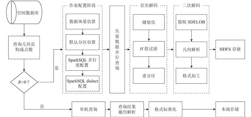
| 两步解码式空间矢量数据并行转换算法 |
孙乐乐1( ),金宝轩2,*() ),金宝轩2,*() |
1. 云南师范大学 旅游与地理科学学院,云南 昆明 650500
2. 云南省自然资源厅,云南 昆明 650224 |
|
| Spatial vector data parallel conversion algorithm based on two-step decoding |
| Le-le SUN1(),Bao-xuan JIN2,*() |
1. College of Tourism and Geography Science, Yunnan Normal University, Kunming 650500, China
2. Yunnan Provincial Department of Natural Resources, Kunming 650224, China |
| 1 |
李军, 费川云 地球空间数据集成研究概况[J]. 地理科学进展, 2000, 19 (3): 203- 211
LI Jun, FEI Chuan-yun Overview of study on geo-spatial data integration[J]. Progress in Geography, 2000, 19 (3): 203- 211
doi: 10.3969/j.issn.1007-6301.2000.03.002
|
| 2 |
李清泉, 李德仁 大数据GIS[J]. 武汉大学学报: 信息科学版, 2014, 39 (6): 641- 644
LI Qing-quan, LI De-ren Big data GIS[J]. Geomatics and Information Science of Wuhan University, 2014, 39 (6): 641- 644
|
| 3 |
人民网. 土地调查国家级数据库实现全国“一张图”[EB/OL]. (2015-01-02)[2019-12-24]. http://scitech.people.com.cn/n/2015/0102/c1057-26311822.html.
|
| 4 |
人民日报. 首次全国地理国情普查完成[EB/OL]. (2017-01-03)[2019-12-24]. http://www.gov.cn/xinwen/2017-01/03/content_5155812.htm.
|
| 5 |
乐鹏, 吴昭炎, 上官博屹 基于Spark的分布式空间数据存储结构设计与实现[J]. 武汉大学学报: 信息科学版, 2018, 43 (12): 542- 549
YUE Peng, WU Zhao-yan, SHANGGUAN Bo-yi Design and implement of a distributed geospatial data storage structure based on spark[J]. Geomatics and Information Science of Wuhan University, 2018, 43 (12): 542- 549
|
| 6 |
YUE P, TAN Z GIS databases and NoSQL databases[J]. Comprehensive Geographic Information Systems, 2018, 6 (1): 50- 79
|
| 7 |
LI W, SONG M, ZHOU B, et al Performance improvement techniques for geospatial web services in a cyberinfrastructure environment: a case study with a disaster management portal[J]. Computers Environment and Urban Systems, 2015, 54 (3): 314- 325
|
| 8 |
陈德权 基于GeoJSON的WFS实现方式[J]. 测绘科学技术学报, 2011, 28 (1): 66- 69
CHEN De-quan The realization of WFS based on GeoJSON[J]. Journal of Geomatics Science and Technology, 2011, 28 (1): 66- 69
doi: 10.3969/j.issn.1673-6338.2011.01.016
|
| 9 |
龚健雅, 贾文珏, 陈玉敏, 等 从平台GIS到跨平台互操作GIS的发展[J]. 武汉大学学报: 信息科学版, 2004, 29 (11): 985- 989
GONG Jian-ya, JIA Wen-jue, CHEN Yu-min, et al Development from platform GIS to cross-platform interoperable GIS[J]. Geomatics and Information Science of Wuhan University, 2004, 29 (11): 985- 989
|
| 10 |
占美志, 何政伟, 李程 基于GML的空间数据集成技术研究[J]. 地理信息世界, 2014, (2): 29- 32
ZHAN Zhi-mei, HE Zheng-wei, LI Cheng Research of integration technology of spatial data based on GML[J]. Geomatics World, 2014, (2): 29- 32
doi: 10.3969/j.issn.1672-1586.2014.02.008
|
| 11 |
ASTRIANI W, TRISMININGSIH R Extraction, transformation, and loading (ETL) module for hotspot spatial data warehouse using Geokettle[J]. Procedia Environmental Sciences, 2016, 33: 626- 634
doi: 10.1016/j.proenv.2016.03.117
|
| 12 |
裴莲莲, 唐建智, 毕小硕 多源空间大数据的获取及在城市规划中的应用[J]. 地理信息世界, 2019, 26 (1): 13- 17
PEI Lian-lian, TANG Jian-zhi, BI Xiao-shuo The acquisition of multi-source spatial data and its application to urban planning[J]. Geomatics World, 2019, 26 (1): 13- 17
doi: 10.3969/j.issn.1672-1586.2019.01.003
|
| 13 |
ANEJIONU O C D, THAKURIAH P, MCHUGH A, et al Spatial urban data system: a cloud-enabled big data infrastructure for social and economic urban analytics[J]. Future Generation Computer Systems, 2019, 98 (9): 456- 473
|
| 14 |
姚晓闯. 矢量大数据管理关键技术研究 [D]. 北京: 中国农业大学, 2017: 48.
YAO Xiao-chuang. Research on key technologies of vector big data management [D]. Beijing: China Agricultural University, 2017: 48.
|
| 15 |
张少将. 基于Hadoop的地理空间大数据存储与查询技术[D]. 西安: 西安电子科技大学, 2017: 34.
ZHANG Shao-jiang. Hadoop-based geospatial data storage and query technology [D]. Xi’an: Xidian University, 2017: 34.
|
| 16 |
周经纬. 矢量大数据高性能计算模型及关键技术研究[D]. 杭州: 浙江大学, 2016: 89.
ZHOU Jing-wei. Research on big vector data’s high performance computing model and key technologies [D]. Hangzhou: Zhejiang University, 2016: 89.
|
| 17 |
李家, 曹威 Oracle Spatial空间数据在ArcSDE中的图层注册[J]. 计算机系统应用, 2015, 24 (1): 143- 146
LI Jia, CAO Wei Layer register of Oracle Spatial data in ArcSDE[J]. Computer Systems and Applications, 2015, 24 (1): 143- 146
doi: 10.3969/j.issn.1003-3254.2015.01.026
|
| 18 |
吴锦超 基于Oracle的ArcSDE数据迁移[J]. 测绘与空间地理信息, 2018, 41 (3): 154- 155
WU Jin-chao Data migration of ArcSDE based on Oracle[J]. Geomatics and Spatial Information Technology, 2018, 41 (3): 154- 155
doi: 10.3969/j.issn.1672-5867.2018.03.048
|
| 19 |
YAO X, MOKBEL M F, ALARABI L, et al Spatial coding-based approach for partitioning big spatial data in Hadoop[J]. Computers and Geosciences, 2017, 106: 60- 67
doi: 10.1016/j.cageo.2017.05.014
|
| 20 |
ELDAWY A, ALARABI L, MOKBEL M F Spatial partitioning techniques in Spatial Hadoop[J]. Proceedings of the VLDB Endowment, 2015, 8 (12): 1602- 1605
doi: 10.14778/2824032.2824057
|
| 21 |
ZEILER M. Modeling our world: the ESRI guide to geodatabase design [M]. Redlands: ESRI Press, 1999: 8.
|
| 22 |
ESRI. ArcGIS所支持的Oracle数据类型[EB/OL]. (2014-05-10)[2019-08-01]. http://resources.arcgis.com/zh-cn/help/main/10.2/index.html#/na/002n00000067000000/.
|
| 23 |
王怀, 樊文锋, 叶芳宏 基于ArcSDE的省级基础地理信息数据库系统建设[J]. 地理信息世界, 2011, 9 (3): 65- 69
WANG Huai, FAN Wen-feng, YE Fang-hong Building provincial fundamental geographic information database system based on ArcSDE[J]. Geomatics World, 2011, 9 (3): 65- 69
doi: 10.3969/j.issn.1672-1586.2011.03.013
|
| 24 |
周龙廷. 直接访问ArcSDE空间数据模型的技术方法研究[D]. 上海: 华东师范大学, 2011: 30.
ZHOU Long-ting. The technical research of methods to direct access to ArcSDE spatial data model [D]. Shanghai: East China Normal University, 2011: 30.
|
|
Viewed |
|
|
|
Full text
|
|
|
|
|
Abstract
|
|
|
|
|
Cited |
|
|
|
|
| |
Shared |
|
|
|
|
| |
Discussed |
|
|
|
|